IMAGES TAKEN NEAR TO
Court Road, DEAL, CT14 7RG
Introduction
This page details the photographs taken nearby to Court Road, CT14 7RG by members of the Geograph project.
The Geograph project started in 2005 with the aim of publishing, organising and preserving representative images for every square kilometre of Great Britain, Ireland and the Isle of Man.

There are currently over 7.5m images from over14,400 individuals and you can help contribute to the project by visiting https://www.geograph.org.uk
Image Map
Images are licensed for reuse under creativecommons.org/licenses/by-sa/2.0
Notes
- Clicking on the map will re-center to the selected point.
- The higher the marker number, the further away the image location is from the centre of the postcode.
Image Listing (77 Images Found)
Images are licensed for reuse under creativecommons.org/licenses/by-sa/2.0
Image
Details
Distance
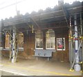
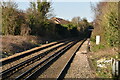
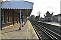
1
Walmer railway station, Kent
Opened in 1881 jointly by the South Eastern Railway and the London, Chatham and Dover Railway on the Deal to Dover line. View north east towards Deal and Ramsgate.
Image: © Nigel Thompson
Taken: 7 Jan 2012
0.05 miles
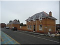
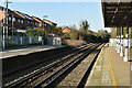
7
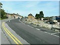
Station Drive, Walmer
A closer view of the station building and new house referred to in Image
Image: © John Baker
Taken: 25 Sep 2011
0.06 miles
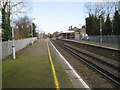
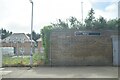
8
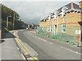
A nearer view
Of Image but in this view Walmer railway station is visible.
Upon completion, the houses were numbered Image
Image: © John Baker
Taken: 6 Oct 2013
0.06 miles