IMAGES TAKEN NEAR TO
Reading Close, DEAL, CT14 7RD
Introduction
This page details the photographs taken nearby to Reading Close, CT14 7RD by members of the Geograph project.
The Geograph project started in 2005 with the aim of publishing, organising and preserving representative images for every square kilometre of Great Britain, Ireland and the Isle of Man.

There are currently over 7.5m images from over14,400 individuals and you can help contribute to the project by visiting https://www.geograph.org.uk
Image Map
Images are licensed for reuse under creativecommons.org/licenses/by-sa/2.0
Notes
- Clicking on the map will re-center to the selected point.
- The higher the marker number, the further away the image location is from the centre of the postcode.
Image Listing (94 Images Found)
Images are licensed for reuse under creativecommons.org/licenses/by-sa/2.0
Image
Details
Distance
2
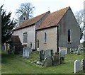
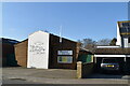
Old St Mary's, Upper Walmer
Part 11th Century church, notable for visits by the Duke of Wellington.
Image: © David Buckden
Taken: 11 Mar 2009
0.05 miles
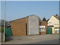
5
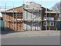
Walmer Chapel, Station Road
I have been unable to discover why scaffolding has been erected on this building.
Image: © John Baker
Taken: 20 Mar 2016
0.07 miles

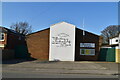
8

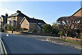
Millers Retreat, Station Road
The development was built on Image
Image: © John Baker
Taken: 27 May 2020
0.11 miles