IMAGES TAKEN NEAR TO
Station Road, DEAL, CT14 7QR
Introduction
This page details the photographs taken nearby to Station Road, CT14 7QR by members of the Geograph project.
The Geograph project started in 2005 with the aim of publishing, organising and preserving representative images for every square kilometre of Great Britain, Ireland and the Isle of Man.

There are currently over 7.5m images from over14,400 individuals and you can help contribute to the project by visiting https://www.geograph.org.uk
Image Map
Images are licensed for reuse under creativecommons.org/licenses/by-sa/2.0
Notes
- Clicking on the map will re-center to the selected point.
- The higher the marker number, the further away the image location is from the centre of the postcode.
Image Listing (67 Images Found)
Images are licensed for reuse under creativecommons.org/licenses/by-sa/2.0
Image
Details
Distance
5
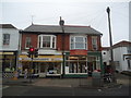
Newsagents and Post Office, Upper Walmer
Image: © Stacey Harris
Taken: 17 Feb 2012
0.04 miles
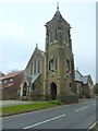
7
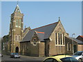
Sacred Heart Catholic Church, Walmer
Church on the junction of the A258 Dover Road (on the left) and Gram's Road (on the right).
Image: © David Anstiss
Taken: 27 Mar 2011
0.05 miles
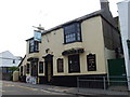
8
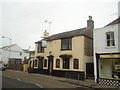
Thompson's Bell public house, Upper Walmer
Image: © Stacey Harris
Taken: 17 Feb 2012
0.05 miles
9
Church of the Sacred Heart, Dover Road, Walmer
Roman Catholic church designed by Peter Paul and Cuthbert Pugin in the late 19th century.
Image: © pam fray
Taken: 9 Oct 2010
0.05 miles
10
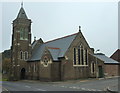
Church of the Sacred Heart, Dover Road, Walmer
Roman Catholic church designed by Peter Paul and Cuthbert Pugin. Late 19th century.
Image: © pam fray
Taken: 9 Oct 2010
0.05 miles