IMAGES TAKEN NEAR TO
Salisbury Road, DEAL, CT14 7QG
Introduction
This page details the photographs taken nearby to Salisbury Road, CT14 7QG by members of the Geograph project.
The Geograph project started in 2005 with the aim of publishing, organising and preserving representative images for every square kilometre of Great Britain, Ireland and the Isle of Man.

There are currently over 7.5m images from over14,400 individuals and you can help contribute to the project by visiting https://www.geograph.org.uk
Image Map
Images are licensed for reuse under creativecommons.org/licenses/by-sa/2.0
Notes
- Clicking on the map will re-center to the selected point.
- The higher the marker number, the further away the image location is from the centre of the postcode.
Image Listing (5 Images Found)
Images are licensed for reuse under creativecommons.org/licenses/by-sa/2.0
Image
Details
Distance
1
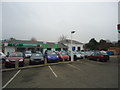
Adamson's Skoda car dealership, Walmer
Image: © Stacey Harris
Taken: 17 Feb 2012
0.01 miles
3

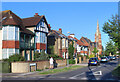
Pennypot Dental Practise, Walmer
On the junction of A258 Dover Road (in front) and Walmer Castle Road (behind).
Looks like a former public house converted into a practise.
Image: © David Anstiss
Taken: 17 Apr 2011
0.16 miles
4
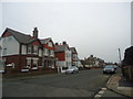
Kelvedon Road, Walmer
A residential street a short way from the sea front.
Image: © Des Blenkinsopp
Taken: 12 Jun 2021
0.16 miles