IMAGES TAKEN NEAR TO
Dover Road, DEAL, CT14 7PQ
Introduction
This page details the photographs taken nearby to Dover Road, CT14 7PQ by members of the Geograph project.
The Geograph project started in 2005 with the aim of publishing, organising and preserving representative images for every square kilometre of Great Britain, Ireland and the Isle of Man.

There are currently over 7.5m images from over14,400 individuals and you can help contribute to the project by visiting https://www.geograph.org.uk
Image Map
Images are licensed for reuse under creativecommons.org/licenses/by-sa/2.0
Notes
- Clicking on the map will re-center to the selected point.
- The higher the marker number, the further away the image location is from the centre of the postcode.
Image Listing (16 Images Found)
Images are licensed for reuse under creativecommons.org/licenses/by-sa/2.0
Image
Details
Distance
1
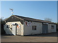
Xtreme RC Store
This small unit is in Walmer Court Farm on the A256 Dover Road.
Image: © David Anstiss
Taken: 17 Apr 2011
0.03 miles
4
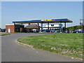
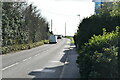
Car wash on the A258 Dover Road
Looks like it used to be a filling station but no sign of petrol pumps now, used as a car wash.
Image: © Nick Smith
Taken: 11 May 2008
0.10 miles
6
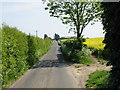
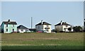
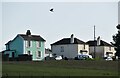
Ripple Road looking towards the A258 Dover Road
Image: © Nick Smith
Taken: 11 May 2008
0.12 miles
7
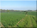
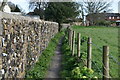
Footpath on Claytons Hill
A path leads from the A258 Dover Road towards Glen Road.
The Firs (wood) is seen on the left.
Image: © David Anstiss
Taken: 17 Apr 2011
0.13 miles
10
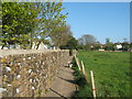
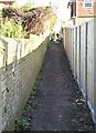
Footpath to Dover Road
This path leads from Coldblow Road, past Clifford Park Caravan Site towards the A258 Road.
Image: © David Anstiss
Taken: 17 Apr 2011
0.16 miles