IMAGES TAKEN NEAR TO
Halliday Drive, DEAL, CT14 7FH
Introduction
This page details the photographs taken nearby to Halliday Drive, CT14 7FH by members of the Geograph project.
The Geograph project started in 2005 with the aim of publishing, organising and preserving representative images for every square kilometre of Great Britain, Ireland and the Isle of Man.

There are currently over 7.5m images from over14,400 individuals and you can help contribute to the project by visiting https://www.geograph.org.uk
Image Map
Images are licensed for reuse under creativecommons.org/licenses/by-sa/2.0
Notes
- Clicking on the map will re-center to the selected point.
- The higher the marker number, the further away the image location is from the centre of the postcode.
Image Listing (177 Images Found)
Images are licensed for reuse under creativecommons.org/licenses/by-sa/2.0
Image
Details
Distance
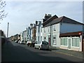
1
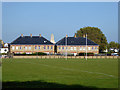
Houses on site of Royal Marine barracks, Walmer
Looking like refurbished military buildings, but actually new build.
Image: © Robin Webster
Taken: 14 Oct 2017
0.01 miles
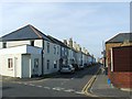
2
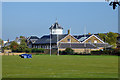
Former barracks gymnasium building, Walmer
Now residential.
Image: © Robin Webster
Taken: 14 Oct 2017
0.04 miles

9
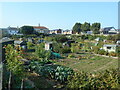
Campbell Road allotments
Ready for harvest. A group of well maintained allotment gardens.
Situated in the heart of town.
Image: © Anthony Vosper
Taken: 22 Sep 2020
0.14 miles
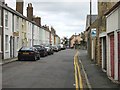
10
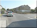
Barracks Development
Looking along Gladstone Road from its junction with Canada Road.
Image: © John Baker
Taken: 27 Aug 2013
0.14 miles