IMAGES TAKEN NEAR TO
Sondes Road, DEAL, CT14 7BW
Introduction
This page details the photographs taken nearby to Sondes Road, CT14 7BW by members of the Geograph project.
The Geograph project started in 2005 with the aim of publishing, organising and preserving representative images for every square kilometre of Great Britain, Ireland and the Isle of Man.

There are currently over 7.5m images from over14,400 individuals and you can help contribute to the project by visiting https://www.geograph.org.uk
Image Map
Images are licensed for reuse under creativecommons.org/licenses/by-sa/2.0
Notes
- Clicking on the map will re-center to the selected point.
- The higher the marker number, the further away the image location is from the centre of the postcode.
Image Listing (724 Images Found)
Images are licensed for reuse under creativecommons.org/licenses/by-sa/2.0
Image
Details
Distance
1
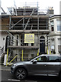
16, Sondes Road
It would appear that the house is being renovated.
Image: © John Baker
Taken: 5 Mar 2018
0.01 miles
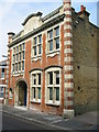
2
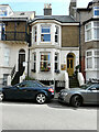
Sondes Lodge, 14, Sondes Road
Planning permission has been granted by Dover District Council under application number DOV/21/00929 for a “change of use to a dwelling house”. At the time of the photograph, Sondes Lodge was a bed and breakfast establishment.
Image: © John Baker
Taken: 28 Jul 2021
0.01 miles
3
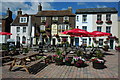
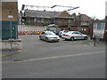
Kings Head, Deal
The Kings Head on Deal seafront.
Image: © Philip Halling
Taken: 18 Jul 2009
0.01 miles
4
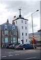
Timeball Tower
Grade II listed. http://www.britishlistedbuildings.co.uk/en-176935-timeball-tower-deal
Image: © N Chadwick
Taken: 28 Aug 2011
0.01 miles
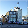
5
The back of Homeleigh, 3, Sondes Road
Seen across a carpark in South Street, planning permission has been granted by Dover District Council under application number DOV/14/00009 for the “erection of dormer roof extensions”. This is the front of Image
Image: © John Baker
Taken: 20 Mar 2016
0.01 miles

8
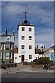
The Time Ball Tower, Deal, Kent
The Time Ball Tower was originally built as one of a chain of semaphore towers which enabled naval ports and ships to communicate with London. The locations of others can often be detected by place names such as Telegraph Hill, Telegraph Farm, etc. In 1855 the building was converted to the Time Ball Tower so that ships anchored in the Downs, the sheltered area of water inside the Goodwin Sands, could set their chronometers. At 12.55 the ball was raised half way, at 12.58 full way and at 1 pm it was dropped. The Tower is now a museum of time and telegraphy.
Image: © Ron Strutt
Taken: 1 Jul 2004
0.02 miles
9
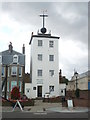
The Time Ball Tower Museum, Prince of Wales Terrace
Built originally as a Semaphore Station in 1795, it was later converted to a time ball tower, used as a means to check the time by shipping passing through or anchored in the English Channel. The ball was raised to the top of its pole and dropped at exactly 1pm each day. Although no longer needed, the ball still drops hourly each day. The photograph was taken at 2pm and the ball has just dropped.
Image: © pam fray
Taken: 25 Jul 2009
0.02 miles
10
Time Ball Tower Museum, Deal
The tall building was built as a naval semaphore station during the Napoleonic Wars. In 1855 it was converted to a Greenwich time reference for shipping. The ball was raised and then dropped at 1 p.m., synchronized with Greenwich electrically via the railway telegraph. This was discontinued in 1927. It is now a museum. A grade II listed building.
Image: © Robin Webster
Taken: 14 Oct 2017
0.02 miles