IMAGES TAKEN NEAR TO
The Maltings, DEAL, CT14 7AR
Introduction
This page details the photographs taken nearby to The Maltings, CT14 7AR by members of the Geograph project.
The Geograph project started in 2005 with the aim of publishing, organising and preserving representative images for every square kilometre of Great Britain, Ireland and the Isle of Man.

There are currently over 7.5m images from over14,400 individuals and you can help contribute to the project by visiting https://www.geograph.org.uk
Image Map
Images are licensed for reuse under creativecommons.org/licenses/by-sa/2.0
Notes
- Clicking on the map will re-center to the selected point.
- The higher the marker number, the further away the image location is from the centre of the postcode.
Image Listing (29 Images Found)
Images are licensed for reuse under creativecommons.org/licenses/by-sa/2.0
Image
Details
Distance
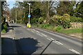
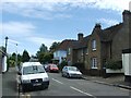
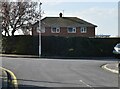
5
Junction of The Maltings with the A258 Dover Road
Image: © Nick Smith
Taken: 11 May 2008
0.12 miles
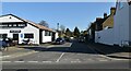
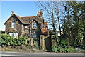
7
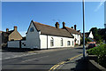
366 Dover Road, Walmer
On the corner of Hawksdown, which it seems to predate. It has a somewhat chapelish air, but has never been mapped as such, or indeed as anything specific.
Image: © Robin Webster
Taken: 12 Jun 2014
0.13 miles