IMAGES TAKEN NEAR TO
The Avenue, DEAL, CT14 6TP
Introduction
This page details the photographs taken nearby to The Avenue, CT14 6TP by members of the Geograph project.
The Geograph project started in 2005 with the aim of publishing, organising and preserving representative images for every square kilometre of Great Britain, Ireland and the Isle of Man.

There are currently over 7.5m images from over14,400 individuals and you can help contribute to the project by visiting https://www.geograph.org.uk
Image Map (Loading...)


Getting Data...Please wait
Leaflet Map data © OpenStreetMap
Images are licensed for reuse under creativecommons.org/licenses/by-sa/2.0
Notes
- Clicking on the map will re-center to the selected point.
- The higher the marker number, the further away the image location is from the centre of the postcode.
Image Listing (454 Images Found)
Images are licensed for reuse under creativecommons.org/licenses/by-sa/2.0
Image
Details
Distance
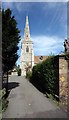
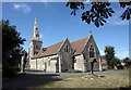
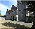
8
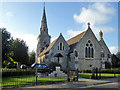
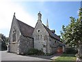
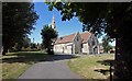
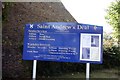
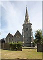
St. Andrew's Church, Deal
A Victorian grade II listed building.
Image: © Robin Webster
Taken: 14 Oct 2017
0.04 miles
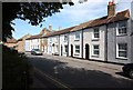
9

26, Nelson Street
Planning permission has been granted by Dover District Council under application number DOV/20/00521 for the “erection of two storey and single storey rear extensions and alterations to the front elevation (existing rear extensions to be demolished)”.
Image: © John Baker
Taken: 13 Sep 2020
0.04 miles