IMAGES TAKEN NEAR TO
West Lea, DEAL, CT14 6TL
Introduction
This page details the photographs taken nearby to West Lea, CT14 6TL by members of the Geograph project.
The Geograph project started in 2005 with the aim of publishing, organising and preserving representative images for every square kilometre of Great Britain, Ireland and the Isle of Man.

There are currently over 7.5m images from over14,400 individuals and you can help contribute to the project by visiting https://www.geograph.org.uk
Image Map
Images are licensed for reuse under creativecommons.org/licenses/by-sa/2.0
Notes
- Clicking on the map will re-center to the selected point.
- The higher the marker number, the further away the image location is from the centre of the postcode.
Image Listing (46 Images Found)
Images are licensed for reuse under creativecommons.org/licenses/by-sa/2.0
Image
Details
Distance
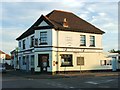
1
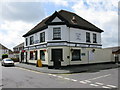
The Jolly Gardener, Golf Road
On the corner of Golf Road with Cannon Street.
Image: © Nick Smith
Taken: 18 May 2009
0.08 miles
4
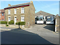
Thomsetts Coaches, 50, Golf Road
Thomsetts Coaches has been providing midi coach and coach hire from Deal since 1929. All excursions are tailored to individual customer requirements, providing a dedicated and professional service http://thomsettscoaches.co.uk/
Image: © John Baker
Taken: 20 Sep 2020
0.12 miles
5
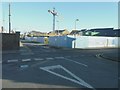
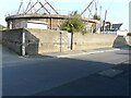
Building site on corner of Cannon Street and Golf Road
Planning permission has been granted by Dover District Council under application number DOV/09/00873 for the “erection of a GP surgery, Community Centre, 28 flats and 41 houses, related infrastructure and car parking”.
Image: © John Baker
Taken: 10 Nov 2013
0.12 miles
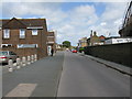
6
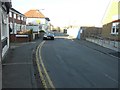
Looking north-northeast along Golf Road
On the left is the nameplate for Sandown Court, while on the opposite side of the road is hoarding that hides a building site. Planning permission has been granted by Dover District Council under application number DOV/09/00873 for the “erection of a GP surgery, Community Centre, 28 flats and 41 houses, related infrastructure and car parking”.
Image: © John Baker
Taken: 10 Nov 2013
0.12 miles
7
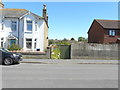
56, Golf Road
A fence has been erected along the side of the house to separate it from a development for which planning permission has been granted by Dover District Council under application number DOV/17/00815 for “the erection of a detached dwelling, creation of vehicular access and parking (existing garage to be demolished)”.
This was Image in September 2016 and before the gate lost its left half.
Image: © John Baker
Taken: 12 May 2019
0.12 miles
8
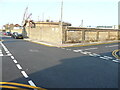
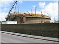
Gas Holder Station, Cannon Street
Dover District Council has authorized that prior approval was not required under application number DOV/ 21/00951 for the “prior approval for the demolition and dismantling of redundant gasholder station”.
The view was from Golf Road.
Image: © John Baker
Taken: 5 Sep 2021
0.12 miles
10
Gas Holder Station, Cannon Street
Dover District Council has authorized that prior approval was not required under application number DOV/ 21/00951 for the “prior approval for the demolition and dismantling of redundant gasholder station”.
The view was from Golf Road.
Image: © John Baker
Taken: 5 Sep 2021
0.13 miles