IMAGES TAKEN NEAR TO
Ark Lane, DEAL, CT14 6PX
Introduction
This page details the photographs taken nearby to Ark Lane, CT14 6PX by members of the Geograph project.
The Geograph project started in 2005 with the aim of publishing, organising and preserving representative images for every square kilometre of Great Britain, Ireland and the Isle of Man.

There are currently over 7.5m images from over14,400 individuals and you can help contribute to the project by visiting https://www.geograph.org.uk
Image Map
Images are licensed for reuse under creativecommons.org/licenses/by-sa/2.0
Notes
- Clicking on the map will re-center to the selected point.
- The higher the marker number, the further away the image location is from the centre of the postcode.
Image Listing (396 Images Found)
Images are licensed for reuse under creativecommons.org/licenses/by-sa/2.0
Image
Details
Distance
1
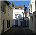
Middle Street
Looking down into Middle Street from Beach Street.
Image: © David Buckden
Taken: 9 Mar 2009
0.01 miles
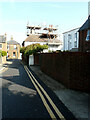
2
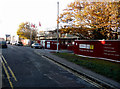
Building site, Ark Lane
Planning permission, with conditions, has been granted by Dover District Council under application number DOV/16/00502 for the “erection of a three storey building incorporating 41 one and two bed sheltered apartments including residents communal areas, refuse and plant, with associated access, parking and landscaping”.
It was a Image in September 2016.
Image: © John Baker
Taken: 8 Nov 2018
0.01 miles
3
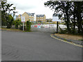
Derelict site, Ark Lane
Planning permission, with conditions, has been granted by Dover District Council under application number DOV/16/00502 for the “erection of a three storey building incorporating 41 one and two bed sheltered apartments including residents communal areas, refuse and plant, with associated access, parking and landscaping”.
Image: © John Baker
Taken: 4 Sep 2016
0.02 miles
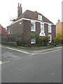
4
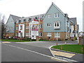
Goodwin Lodge, Ark Lane
This was a Image in November 2018.
Image: © John Baker
Taken: 5 Jan 2020
0.02 miles
5
1, College Road
Viewed from Ark Lane, work is being carried out to the property’s chimneys.
Image: © John Baker
Taken: 20 Sep 2020
0.02 miles
6
1, College Road
This was the back of Image, when work was being carried out to the property’s chimneys. With scaffolding still in place, it appears that the work is still ongoing.
Image: © John Baker
Taken: 18 Oct 2020
0.02 miles
7
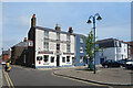
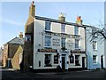
The Saracen's Head in Alfred Square
A traditional looking pub frontage on a small square in an area of mostly old narrow streets.
Shepherd Neame brewery in Faversham traces its origin back to 1698, making it Britain's Oldest Brewer as proclaimed on the front, where the brewer's name features larger than the pub name.
A history of Shepherd Neame brewery is on https://www.shepherdneame.co.uk/brewery/brewery-history
Image: © Des Blenkinsopp
Taken: 17 Jun 2021
0.04 miles
8
Alfred Square, Deal
The Saracen's Head pub in Alfred Square.
Image: © Rosie Burnham
Taken: 16 Feb 2006
0.04 miles
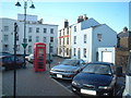
10
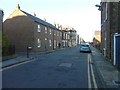
Looking north-northwest along College Road
The nameplate on the left is that of Ark Lane, while the tall house, beyond the terrace, is number 11, whose frontage is clad in scaffolding to enable maintenance to be carried out.
Image: © John Baker
Taken: 10 Nov 2013
0.05 miles