IMAGES TAKEN NEAR TO
Western Road, DEAL, CT14 6PJ
Introduction
This page details the photographs taken nearby to Western Road, CT14 6PJ by members of the Geograph project.
The Geograph project started in 2005 with the aim of publishing, organising and preserving representative images for every square kilometre of Great Britain, Ireland and the Isle of Man.

There are currently over 7.5m images from over14,400 individuals and you can help contribute to the project by visiting https://www.geograph.org.uk
Image Map
Images are licensed for reuse under creativecommons.org/licenses/by-sa/2.0
Notes
- Clicking on the map will re-center to the selected point.
- The higher the marker number, the further away the image location is from the centre of the postcode.
Image Listing (139 Images Found)
Images are licensed for reuse under creativecommons.org/licenses/by-sa/2.0
Image
Details
Distance


5
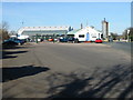
Entrance to builder's merchant and timber yard, Deal
Image: © Nick Smith
Taken: 9 Feb 2008
0.08 miles
6
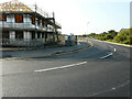
Court Marsh Road, Pottery Grove
Pottery Grove is the name, which has been given to this housing estate.
Image: © John Baker
Taken: 5 Sep 2021
0.08 miles