IMAGES TAKEN NEAR TO
Middle Street, DEAL, CT14 6JZ
Introduction
This page details the photographs taken nearby to Middle Street, CT14 6JZ by members of the Geograph project.
The Geograph project started in 2005 with the aim of publishing, organising and preserving representative images for every square kilometre of Great Britain, Ireland and the Isle of Man.

There are currently over 7.5m images from over14,400 individuals and you can help contribute to the project by visiting https://www.geograph.org.uk
Image Map
Images are licensed for reuse under creativecommons.org/licenses/by-sa/2.0
Notes
- Clicking on the map will re-center to the selected point.
- The higher the marker number, the further away the image location is from the centre of the postcode.
Image Listing (516 Images Found)
Images are licensed for reuse under creativecommons.org/licenses/by-sa/2.0
Image
Details
Distance
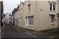
1

Middle Street
Narrow street running north/south in the area between Beach Street and High Street.
Image: © Ian Capper
Taken: 25 Jan 2014
0.00 miles
2
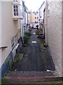
Portobello Court seen from Middle Street, Deal
This is the view down Portobello Court, seen from Middle Street in Deal. This is part of the Middle Street Deal Conservation Area, which in 1968 was the first Conservation Area in Kent to be designated. Its distinctive character is typified by the central axis of mainly Georgian terraced houses clustered around Middle Street and extending up to High Street or Beach Street.
The press gang operated around these streets and smugglers' hiding places are still being found in local houses. The streets once thronged with soldiers, sailors and fishermen. Almost every building was either a pub, a lodging house or a brothel. As it was the boatmen's area, the street was crowded with pilots, net-makers, sail-makers, rope-makers and boatbuilders. Most of the numerous pubs have closed but many of the old inns survive as private houses and bear the original pub names - the Deal Cutter and the Scarborough Cat for example.
Image: © Marathon
Taken: 25 Jan 2014
0.01 miles
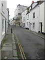
3
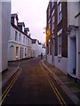
Middle Street, Deal
This is the view down Middle Street in Deal, with Silver Street the next turning on the left. It is all part of the Middle Street Deal Conservation Area, which in 1968 was the first Conservation Area in Kent to be designated. Its distinctive character is typified by the central axis of mainly Georgian terraced houses clustered around Middle Street and extending up to High Street or Beach Street.
The press gang operated around these streets and smugglers' hiding places are still being found in local houses. The streets once thronged with soldiers, sailors and fishermen. Almost every building was either a pub, a lodging house or a brothel. As it was the boatmen's area, the street was crowded with pilots, net-makers, sail-makers, rope-makers and boatbuilders. Most of the numerous pubs have closed but many of the old inns survive as private houses and bear the original pub names - the Deal Cutter and the Scarborough Cat for example.
Image: © Marathon
Taken: 25 Jan 2014
0.01 miles
4

The Ship Inn
Grade II listed. https://www.britishlistedbuildings.co.uk/101261597-the-ship-inn-deal
Image: © N Chadwick
Taken: 15 Feb 2018
0.01 miles
5
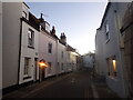
Middle Street, Deal
This is the view looking along Middle Street in Deal. The next road on the right is Silver Street and before it, on the left, is the Ship Inn. It is all part of the Middle Street Deal Conservation Area, which in 1968 was the first Conservation Area in Kent to be designated. Its distinctive character is typified by the central axis of mainly Georgian terraced houses clustered around Middle Street and extending up to High Street or Beach Street.
The press gang operated around these streets and smugglers' hiding places are still being found in local houses. The streets once thronged with soldiers, sailors and fishermen. Almost every building was either a pub, a lodging house or a brothel. As it was the boatmen's area, the street was crowded with pilots, net-makers, sail-makers, rope-makers and boatbuilders. Most of the numerous pubs have closed but many of the old inns survive as private houses and bear the original pub names - the Deal Cutter and the Scarborough Cat for example. The Ship Inn though survives - see https://www.geograph.org.uk/photo/7360474
Image: © Marathon
Taken: 8 Dec 2022
0.01 miles
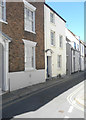
7
Middle Street, Deal
Golden Street leads off to the right and the Ship Inn can be seen on the left. This is part of Deal's Middle Street conservation area.
Image: © Stephen McKay
Taken: 11 Dec 2021
0.02 miles
8
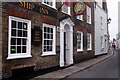
The Ship Inn, Deal
The Ship Inn on Middle Street dates from the late 18th or early 19th centuries and is grade II listed. It has a genuine maritime history, still reflected in many of the artefacts found within; in 1876 it was recorded as taking in survivors from the wreck of the steamship 'Strathclyde' that sank with the loss of 38 lives.
Image: © Stephen McKay
Taken: 11 Dec 2021
0.02 miles
9

The Ship Inn, Deal at dusk in December
This is the view looking along Middle Street in Deal. The next road on the left is Golden Street. It is all part of the Middle Street Deal Conservation Area, which in 1968 was the first Conservation Area in Kent to be designated. Its distinctive character is typified by the central axis of mainly Georgian terraced houses clustered around Middle Street and extending up to High Street or Beach Street.
The press gang operated around these streets and smugglers' hiding places are still being found in local houses. The streets once thronged with soldiers, sailors and fishermen. Almost every building was either a pub, a lodging house or a brothel. As it was the boatmen's area, the street was crowded with pilots, net-makers, sail-makers, rope-makers and boatbuilders. Most of the numerous pubs have closed but many of the old inns survive as private houses and bear the original pub names - the Deal Cutter and the Scarborough Cat for example. One that has survived is the Ship Inn, as seen here on a bitter December evening.
Image: © Marathon
Taken: 8 Dec 2022
0.02 miles
10
Alterations to 1, Golden Street
Planning permission has been granted by Dover District Council under application numbers DOV/15/00500 for the “erection of a roof extension, insertion of a side roof-light and replacement window”; DOV/15/00501 for the “erection of roof extensions, insertion of a side roof-light and replacement window and associated internal alterations”; DOV/15/00975 for the “erection of a replacement second floor front dormer window and replacement and repair of second floor gutter” and DOV/15/00976 for the “erection of a replacement second floor front dormer window and replacement and repair of second floor gutter with associated internal and external alterations”.
The house stands on the corner of Middle Street, is grade II listed and dates from the mid 19th century http://www.britishlistedbuildings.co.uk/en-177084-1-golden-street-deal-kent#.WKnuI_5vjcc
This view shows Image in September 2020.
Image: © John Baker
Taken: 5 Feb 2017
0.02 miles