IMAGES TAKEN NEAR TO
Middle Street, DEAL, CT14 6JN
Introduction
This page details the photographs taken nearby to Middle Street, CT14 6JN by members of the Geograph project.
The Geograph project started in 2005 with the aim of publishing, organising and preserving representative images for every square kilometre of Great Britain, Ireland and the Isle of Man.

There are currently over 7.5m images from over14,400 individuals and you can help contribute to the project by visiting https://www.geograph.org.uk
Image Map
Images are licensed for reuse under creativecommons.org/licenses/by-sa/2.0
Notes
- Clicking on the map will re-center to the selected point.
- The higher the marker number, the further away the image location is from the centre of the postcode.
Image Listing (650 Images Found)
Images are licensed for reuse under creativecommons.org/licenses/by-sa/2.0
Image
Details
Distance
1
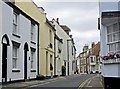
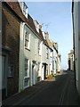
Middle Street, Deal
Looking north from the junction with Brewer Street
Image: © Paul Harrop
Taken: 17 Jul 2012
0.00 miles
2
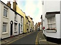
Middle Street from the corner with Brewer Street
Charming old houses in the Conservation Area of Deal. The next turning on the right, just past the car, is Coppin Street.
Image: © Rose and Trev Clough
Taken: 14 Oct 2009
0.00 miles
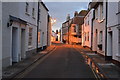
4

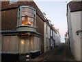
93, Middle Street
The house appears to be undergoing an internal refurbishment.
Image: © John Baker
Taken: 12 May 2019
0.01 miles
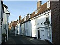
8
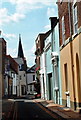
Coppin Street, Deal, seen from Middle Street
This is the view from Middle Street in Deal, looking down Coppin Street towards the seafront. It is all part of the Middle Street Deal Conservation Area, which in 1968 was the first Conservation Area in Kent to be designated. Its distinctive character is typified by the central axis of mainly Georgian terraced houses clustered around Middle Street and extending up to High Street or Beach Street.
The press gang operated around these streets and smugglers' hiding places are still being found in local houses. The streets once thronged with soldiers, sailors and fishermen. Almost every building was either a pub, a lodging house or a brothel. As it was the boatmen's area, the street was crowded with pilots, net-makers, sail-makers, rope-makers and boatbuilders. Most of the numerous pubs have closed but many of the old inns survive as private houses and bear the original pub names - the Deal Cutter and the Scarborough Cat for example.
Image: © Marathon
Taken: 8 Dec 2022
0.02 miles
9
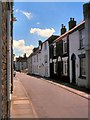
Deal, Middle Street
Many of the mid to late eighteenth century terraced houses on this narrow street are grade II listed buildings (http://www.britishlistedbuildings.co.uk/england/kent/deal British Listed Buildings).
Image: © David Dixon
Taken: Unknown
0.02 miles
10
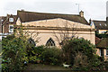
Former Central Hall
Former baptist chapel, reputed to be 17th century but of mid 19th century appearance. Grade II listed - see www.historicengland.org.uk/listing/the-list/list-entry/1343692.
Image: © Ian Capper
Taken: 25 Jan 2014
0.02 miles