IMAGES TAKEN NEAR TO
College Road, DEAL, CT14 6BT
Introduction
This page details the photographs taken nearby to College Road, CT14 6BT by members of the Geograph project.
The Geograph project started in 2005 with the aim of publishing, organising and preserving representative images for every square kilometre of Great Britain, Ireland and the Isle of Man.

There are currently over 7.5m images from over14,400 individuals and you can help contribute to the project by visiting https://www.geograph.org.uk
Image Map
Images are licensed for reuse under creativecommons.org/licenses/by-sa/2.0
Notes
- Clicking on the map will re-center to the selected point.
- The higher the marker number, the further away the image location is from the centre of the postcode.
Image Listing (251 Images Found)
Images are licensed for reuse under creativecommons.org/licenses/by-sa/2.0
Image
Details
Distance
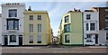
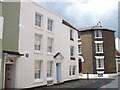
1
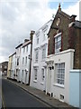
Sydenham Road
Mid 19th century street linking Sandown Road and College Road (seen in the background). The 1872 town plan calls it Fisherman's Row, but by the time of the 1898 1:2500 map it had received its current name.
Image: © Ian Capper
Taken: 25 Jan 2014
0.04 miles
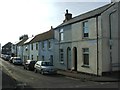
2
Renovation of 19, Sydenham Road
The house also stands on the corner of Sandown Road. A board, attached to the side wall, indicates that D Smith and Sons, general building contractors, are carrying out the work.
This image shows Image after renovation.
Image: © John Baker
Taken: 5 Feb 2017
0.05 miles
4
The house where Charles Hawtrey lived, Middle Street
The blue plaque on the left of the building states that "Charles Hawtrey 1914-1988 Film, Theatre, Radio and Television Actor Lived Here".
Image: © pam fray
Taken: 25 Jul 2009
0.05 miles
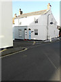
6
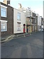
43 College Road
This is the house where scaffolding has been erected on its frontage as far as the second storey.
Image: © John Baker
Taken: 27 Jan 2014
0.05 miles
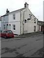
7
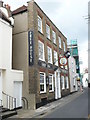
The Ship Inn. 141 Middle Street
A popular free house in Deal.
Image: © pam fray
Taken: 25 Jul 2009
0.06 miles
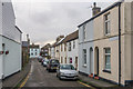
9
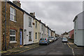
Sandown Road
A north/south road running into Alfred Square and then Middle Street, seen in the far distance. In fact the 1872 1:2500 map names it as Middle Street too, it not being until the 1898 map that it is shown with its current name. The nearest cottages have a name plaque, Tustins Cottages - their appearance suggest Edwardian, although they do not appear on the 1906-7 1:2500 map. The blocks beyond are much older, appearing on the 1873 1:500 town plan as Alexandra Cottages.
Image: © Ian Capper
Taken: 25 Jan 2014
0.06 miles