IMAGES TAKEN NEAR TO
St. Andrews Road, DEAL, CT14 6AT
Introduction
This page details the photographs taken nearby to St. Andrews Road, CT14 6AT by members of the Geograph project.
The Geograph project started in 2005 with the aim of publishing, organising and preserving representative images for every square kilometre of Great Britain, Ireland and the Isle of Man.

There are currently over 7.5m images from over14,400 individuals and you can help contribute to the project by visiting https://www.geograph.org.uk
Image Map
Images are licensed for reuse under creativecommons.org/licenses/by-sa/2.0
Notes
- Clicking on the map will re-center to the selected point.
- The higher the marker number, the further away the image location is from the centre of the postcode.
Image Listing (530 Images Found)
Images are licensed for reuse under creativecommons.org/licenses/by-sa/2.0
Image
Details
Distance
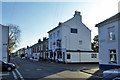
7
View along the northern end of St Andrew's road
The church is St Andrew's church and is in TR3752 shown here Image
Image: © Nick Smith
Taken: 3 Sep 2011
0.05 miles
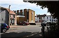
8
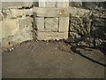
Ordnance Survey bolt on St Andrews Church
Ordnance Survey benchmark with bolt on the north-east face of buttress at St Andrews Church, at south-east corner of the tower. This benchmark was established in 1851 during the First primary levelling of England & Wales, and was levelled with a height of 15.6260 feet (4.7628 metres) above mean sea level (Liverpool datum). It was included as a side level on the London to Dover levelling line. The surveyor's description was "No. 366(e). St. Andrew's New Church, West-street. Bolt in South-west [sic] corner of tower ; 0.58 ft. above surface (p197)." It is now partially hidden owing to resurfacing of the car park.
Image: © Shantavira
Taken: 10 Aug 2012
0.05 miles
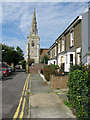
9
Trinity Church
On the junction of Union Road (on the right) and West Street (on the left).
Image: © David Anstiss
Taken: 30 Oct 2010
0.06 miles