IMAGES TAKEN NEAR TO
Betteshanger, DEAL, CT14 0NT
Introduction
This page details the photographs taken nearby to CT14 0NT by members of the Geograph project.
The Geograph project started in 2005 with the aim of publishing, organising and preserving representative images for every square kilometre of Great Britain, Ireland and the Isle of Man.

There are currently over 7.5m images from over14,400 individuals and you can help contribute to the project by visiting https://www.geograph.org.uk
Image Map (Loading...)


Getting Data...Please wait
Leaflet Map data © OpenStreetMap
Images are licensed for reuse under creativecommons.org/licenses/by-sa/2.0
Notes
- Clicking on the map will re-center to the selected point.
- The higher the marker number, the further away the image location is from the centre of the postcode.
Image Listing (16 Images Found)
Images are licensed for reuse under creativecommons.org/licenses/by-sa/2.0
Image
Details
Distance
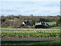
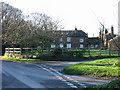
2
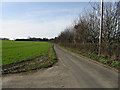
Road to Home Farm and Little Betteshanger
Image: © Nick Smith
Taken: 3 Feb 2008
0.06 miles
3
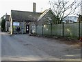
Home Farm and Home Farm cottages, Little Betteshanger.
View across farmland to the farm house and cottages.
Image: © Nick Smith
Taken: 4 Jan 2007
0.08 miles
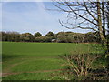
5

Bridleway to Betteshanger
This tree-lined path leads from Home Farm, Little Betteshanger towards Northbourne Park School in Betteshanger.
Image: © David Anstiss
Taken: 17 Apr 2011
0.12 miles
6
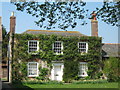
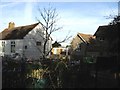
The White House, Little Bettehanger
Beside Mill House.
Image: © David Anstiss
Taken: 17 Apr 2011
0.16 miles
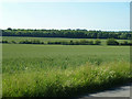
7
Farmland to the W of the road to Home Farm
Image: © Nick Smith
Taken: 3 Feb 2008
0.18 miles
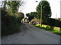
8
Road junction near Northbourne school.
Road junctions and house near Northbourne school (not Northbourne Park school)
Image: © Nick Smith
Taken: 4 Jan 2007
0.18 miles