IMAGES TAKEN NEAR TO
Betteshanger, DEAL, CT14 0NS
Introduction
This page details the photographs taken nearby to CT14 0NS by members of the Geograph project.
The Geograph project started in 2005 with the aim of publishing, organising and preserving representative images for every square kilometre of Great Britain, Ireland and the Isle of Man.

There are currently over 7.5m images from over14,400 individuals and you can help contribute to the project by visiting https://www.geograph.org.uk
Image Map
Images are licensed for reuse under creativecommons.org/licenses/by-sa/2.0
Notes
- Clicking on the map will re-center to the selected point.
- The higher the marker number, the further away the image location is from the centre of the postcode.
Image Listing (8 Images Found)
Images are licensed for reuse under creativecommons.org/licenses/by-sa/2.0
Image
Details
Distance
1
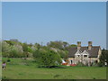
Burnt Barn Cottages
As seen from a bridleway from Little Betteshanger to Northbourne Park School.
Image: © David Anstiss
Taken: 17 Apr 2011
0.02 miles
2
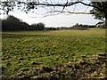
View across the fields towards Betteshanger
Image: © Nick Smith
Taken: 3 Feb 2008
0.15 miles
3

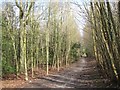
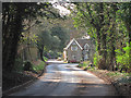
Looking E along a tree lined road towards Northbourne
Image: © Nick Smith
Taken: 3 Feb 2008
0.17 miles
4

Bridleway to Betteshanger
This tree-lined path leads from Home Farm, Little Betteshanger towards Northbourne Park School in Betteshanger.
Image: © David Anstiss
Taken: 17 Apr 2011
0.19 miles
5
Caesar's Camp Plantation
Footpath to Northbourne Road.
Image: © Oast House Archive
Taken: 11 Mar 2012
0.20 miles
6
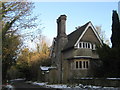
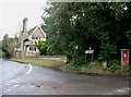
The Cloisters
On the road through Betteshanger.
A Grade II Listed Estate Cottage on the Northbourne Park estate.
See http://www.britishlistedbuildings.co.uk/en-428121-the-cloisters-northbourne for more details.
Image: © David Anstiss
Taken: 26 Dec 2010
0.21 miles
8
Lower Lodge
Grade II listed http://list.english-heritage.org.uk/resultsingle.aspx?uid=1236990 lodge at the start of Church Road.
Image: © Oast House Archive
Taken: 11 Mar 2012
0.23 miles