IMAGES TAKEN NEAR TO
Northbourne, DEAL, CT14 0LW
Introduction
This page details the photographs taken nearby to CT14 0LW by members of the Geograph project.
The Geograph project started in 2005 with the aim of publishing, organising and preserving representative images for every square kilometre of Great Britain, Ireland and the Isle of Man.

There are currently over 7.5m images from over14,400 individuals and you can help contribute to the project by visiting https://www.geograph.org.uk
Image Map (Loading...)


Getting Data...Please wait
Leaflet Map data © OpenStreetMap
Images are licensed for reuse under creativecommons.org/licenses/by-sa/2.0
Notes
- Clicking on the map will re-center to the selected point.
- The higher the marker number, the further away the image location is from the centre of the postcode.
Image Listing (101 Images Found)
Images are licensed for reuse under creativecommons.org/licenses/by-sa/2.0
Image
Details
Distance
1
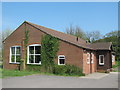
Northbourne Community Centre
On the Drove. Beside a recreational ground.
Image: © David Anstiss
Taken: 17 Apr 2011
0.03 miles
2
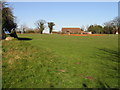
Northbourne recreation ground and pavilion
Image: © Nick Smith
Taken: 17 Feb 2008
0.05 miles
3
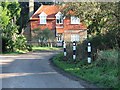
House at the end of The Drove, Northbourne.
Image: © Nick Smith
Taken: 3 Feb 2007
0.05 miles
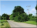
4
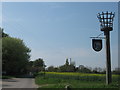
Beacon in Northbourne
Beside The Drove and opposite Northbourne Church (St. Augustine's).
Part of the millennium celebrations, various village got beacons to light on the millennium eve.
This beacon also has a combined village sign attached to it.
Image: © David Anstiss
Taken: 17 Apr 2011
0.07 miles
5

Betteshanger, Finglesham, Ham and Northbourne Village Sign
Attached to Image
These four close villages do not have individual village signs, but are combined on this sign.
Image: © David Anstiss
Taken: 17 Apr 2011
0.07 miles
7
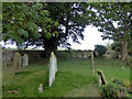
Former triangular enclosure, Northbourne churchyard
A stub of wall at an angle to the main churchyard wall to the left of the yew, another stub by the bush and a line of footings probably for railings, including what looks like a step, remain of a triangular enclosure completed by the main wall. At least five graves with stones and a tablet on the right stub wall are within.
Image: © Robin Webster
Taken: 14 Oct 2017
0.08 miles
8
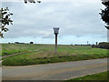
Beacon, Northbourne
Across The Drove from the churchyard.
Image: © Robin Webster
Taken: 14 Oct 2017
0.08 miles
9
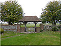
Churchyard lych gate, Northbourne
To The Drove, where easy but limited parking is available.
Image: © Robin Webster
Taken: 14 Oct 2017
0.09 miles
10
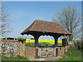
Lych Gate to St.Augustine's Church Northbourne
This gate leads from the church onto the Drove.
In the background, golden fields of oil seed rape plants.
Image: © David Anstiss
Taken: 17 Apr 2011
0.09 miles