IMAGES TAKEN NEAR TO
Deal Road, DEAL, CT14 0LL
Introduction
This page details the photographs taken nearby to Deal Road, CT14 0LL by members of the Geograph project.
The Geograph project started in 2005 with the aim of publishing, organising and preserving representative images for every square kilometre of Great Britain, Ireland and the Isle of Man.

There are currently over 7.5m images from over14,400 individuals and you can help contribute to the project by visiting https://www.geograph.org.uk
Image Map (Loading...)


Getting Data...Please wait
Leaflet Map data © OpenStreetMap
Images are licensed for reuse under creativecommons.org/licenses/by-sa/2.0
Notes
- Clicking on the map will re-center to the selected point.
- The higher the marker number, the further away the image location is from the centre of the postcode.
Image Listing (96 Images Found)
Images are licensed for reuse under creativecommons.org/licenses/by-sa/2.0
Image
Details
Distance
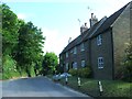
2
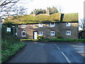
Houses at the junction of The Drove and Deal Road
Image: © Nick Smith
Taken: 3 Feb 2007
0.01 miles
3
St Augustine, Northbourne, Kent - Monument
Image: © John Salmon
Taken: 9 Sep 2008
0.06 miles
4
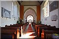
St Augustine, Northbourne, Kent - East end
Image: © John Salmon
Taken: 9 Sep 2008
0.06 miles
5
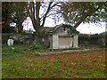
Mausoleum, Northbourne churchyard
A grade II listed 'building'.
Image: © Robin Webster
Taken: 14 Oct 2017
0.06 miles
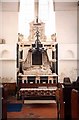
6
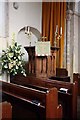
St Augustine, Northbourne, Kent - Pulpit
Image: © John Salmon
Taken: 9 Sep 2008
0.06 miles
7
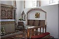
St Augustine, Northbourne, Kent - Piscina & sedilia
Image: © John Salmon
Taken: 9 Sep 2008
0.07 miles
8
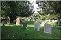
St Augustine, Northbourne, Kent - Churchyard
Image: © John Salmon
Taken: 9 Sep 2008
0.07 miles
9
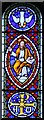
St Augustine, Northbourne, Kent - Window
Image: © John Salmon
Taken: 9 Sep 2008
0.07 miles
10
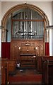
St Augustine, Northbourne, Kent - Organ
Image: © John Salmon
Taken: 9 Sep 2008
0.07 miles