IMAGES TAKEN NEAR TO
Tilmanstone, DEAL, CT14 0JY
Introduction
This page details the photographs taken nearby to CT14 0JY by members of the Geograph project.
The Geograph project started in 2005 with the aim of publishing, organising and preserving representative images for every square kilometre of Great Britain, Ireland and the Isle of Man.

There are currently over 7.5m images from over14,400 individuals and you can help contribute to the project by visiting https://www.geograph.org.uk
Image Map (Loading...)


Getting Data...Please wait
Leaflet Map data © OpenStreetMap
Images are licensed for reuse under creativecommons.org/licenses/by-sa/2.0
Notes
- Clicking on the map will re-center to the selected point.
- The higher the marker number, the further away the image location is from the centre of the postcode.
Image Listing (34 Images Found)
Images are licensed for reuse under creativecommons.org/licenses/by-sa/2.0
Image
Details
Distance
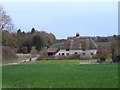
2
Lane junction near Venson Farm
A lane from Thornton heads past the farm towards the A256 Dover Road.
Another lane heads left towards Eastry. A bridleway heads right towards North Court. Venson Farm barn is seen in the background.
Image: © David Anstiss
Taken: 26 Dec 2010
0.02 miles
3
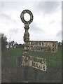
Signpost at S end of Venson Bottom.
An old Eastry RDC (rural district council) finger signpost.
Image: © Nick Smith
Taken: 3 Jan 2007
0.02 miles
4
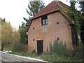
Lower Venson Farm Barn
On a lane leading from Lower Venson Farm towards Eastry.
Image: © David Anstiss
Taken: 26 Dec 2010
0.03 miles
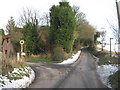
5
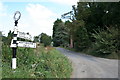
Pike Road, at the junction with Thornton Road
View down Pike Road towards Eastry, at its southerly termination on Thornton Road. In the foreground is a venerable guidepost erected by the former Eastry Rural District Council. Happily, the post has been given a coat of paint since it was photographed in 2007: Image, although the missing limb pointing west along Thornton Road towards Chillenden remains missing, perhaps never to be replaced. Opposite the junction is a public bridleway south to Tilmanstone.
Image: © Hugh Craddock
Taken: 12 Sep 2014
0.03 miles
7
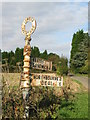
Signpost at Venson Bottom
The signpost Image in context, at Venson Bottom. There are not many of the Eastry Rural District Council signposts remaining.
Image: © Nick Smith
Taken: 20 Oct 2007
0.03 miles
8
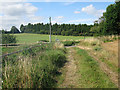
Bridleway to North Court Plantation
A bridleway leads from the lane near Venson Farm. The track leads towards North Court and North Court Lane near Tilmanstone.
Image: © David Anstiss
Taken: 26 Dec 2010
0.03 miles
9
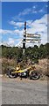
Direction Sign ? Signpost
Located on the northwest side of a T junction on Thornton Road in Eastry parish. 3 arms, 1 missing, and annulus finial. See also https://www.geograph.org.uk/photo/5441057 and https://www.geograph.org.uk/photo/4289585.
Milestone Society National ID: KE_TR3052
Image: © A Johns
Taken: Unknown
0.03 miles
10
Fingerpost on the corner of Pike Road
I was looking for Chillenden, which is the arm which has fallen off on the left. I got it by elimination.
Image: © David Howard
Taken: 22 Jun 2017
0.03 miles