IMAGES TAKEN NEAR TO
Cherry Lane, DEAL, CT14 0HF
Introduction
This page details the photographs taken nearby to Cherry Lane, CT14 0HF by members of the Geograph project.
The Geograph project started in 2005 with the aim of publishing, organising and preserving representative images for every square kilometre of Great Britain, Ireland and the Isle of Man.

There are currently over 7.5m images from over14,400 individuals and you can help contribute to the project by visiting https://www.geograph.org.uk
Image Map (Loading...)


Getting Data...Please wait
Leaflet Map data © OpenStreetMap
Images are licensed for reuse under creativecommons.org/licenses/by-sa/2.0
Notes
- Clicking on the map will re-center to the selected point.
- The higher the marker number, the further away the image location is from the centre of the postcode.
Image Listing (90 Images Found)
Images are licensed for reuse under creativecommons.org/licenses/by-sa/2.0
Image
Details
Distance
1
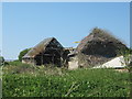
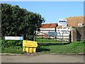
Barn in Great Mongeham Farm
As seen from Pixwell Lane.
This large wooden Kent barn has been left to rot away.
Image: © David Anstiss
Taken: 17 Apr 2011
0.04 miles
2
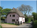
Farm Cottage, Great Mongeham
This thatched cottage is on Cherry Lane.
Image: © David Anstiss
Taken: 17 Apr 2011
0.05 miles
3
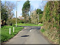
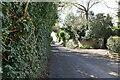
Cherry Lane junction with Northbourne road
Image: © Nick Smith
Taken: 3 Feb 2007
0.06 miles
5
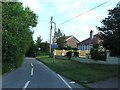
Great Mongeham Farm at junction of Pixwell and Cherry Lanes
Image: © Nick Smith
Taken: 3 Feb 2007
0.06 miles
6
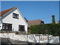
Minimus
House on Cherry Lane in Great Mongeham.
Image: © David Anstiss
Taken: 17 Apr 2011
0.07 miles
7
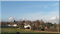
Great Mongeham
St Martin's Church and Cherry Lane.
Image: © Nigel Stevenson
Taken: 10 Jan 2018
0.08 miles
10
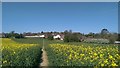
Great Mongeham
Rape seed field adjacent to Cherry Lane.
Image: © Nigel Stevenson
Taken: 18 Apr 2018
0.09 miles