IMAGES TAKEN NEAR TO
Venson Road, DEAL, CT14 0FH
Introduction
This page details the photographs taken nearby to Venson Road, CT14 0FH by members of the Geograph project.
The Geograph project started in 2005 with the aim of publishing, organising and preserving representative images for every square kilometre of Great Britain, Ireland and the Isle of Man.

There are currently over 7.5m images from over14,400 individuals and you can help contribute to the project by visiting https://www.geograph.org.uk
Image Map
Images are licensed for reuse under creativecommons.org/licenses/by-sa/2.0
Notes
- Clicking on the map will re-center to the selected point.
- The higher the marker number, the further away the image location is from the centre of the postcode.
Image Listing (8 Images Found)
Images are licensed for reuse under creativecommons.org/licenses/by-sa/2.0
Image
Details
Distance
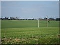
3
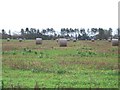
Farmland with straw rolls waiting collection.
Image: © Nick Smith
Taken: 6 Jan 2007
0.09 miles
4
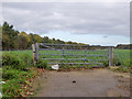
Field gate
Beyond, some sort of beet, this side a useful non-muddy pull-in.
Image: © Robin Webster
Taken: 14 Oct 2017
0.12 miles
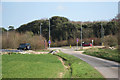
6
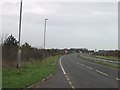
Looking North East along Eastry by-pass.
Entering Eastry by-pass from side road.
Image: © Nick Smith
Taken: 3 Jan 2007
0.15 miles

8
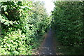
Cycle path alongside A256 Dover Road
Cycle path alongside the west side of the Dover Road (A256), just north of the junction with Thornton Road/Straight Mile near Betteshanger. Black Lane once crossed here, but had probably been obliterated even before the bypass was built.
Image: © Hugh Craddock
Taken: 12 Sep 2014
0.20 miles