IMAGES TAKEN NEAR TO
Updown Road, DEAL, CT14 0EB
Introduction
This page details the photographs taken nearby to Updown Road, CT14 0EB by members of the Geograph project.
The Geograph project started in 2005 with the aim of publishing, organising and preserving representative images for every square kilometre of Great Britain, Ireland and the Isle of Man.

There are currently over 7.5m images from over14,400 individuals and you can help contribute to the project by visiting https://www.geograph.org.uk
Image Map
Images are licensed for reuse under creativecommons.org/licenses/by-sa/2.0
Notes
- Clicking on the map will re-center to the selected point.
- The higher the marker number, the further away the image location is from the centre of the postcode.
Image Listing (18 Images Found)
Images are licensed for reuse under creativecommons.org/licenses/by-sa/2.0
Image
Details
Distance
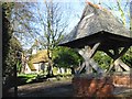
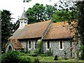
2
Ham church in the snow
Now a private residence I believe.
Image: © Nick Smith
Taken: 20 Dec 2010
0.01 miles
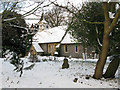
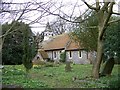
4
Ham church amongst the trees
No longer used as a church, it is listed in a local directory as being a stained glass studio.
Image: © Nick Smith
Taken: 9 Feb 2008
0.02 miles
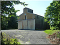
6
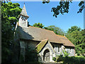
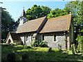
Ham church
St. George's is a grade II*(star) listed building.
Image: © Robin Webster
Taken: 12 Jun 2014
0.02 miles
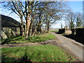
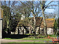
8
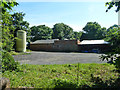
Buildings at Ham Manor
A curious mixture of roof slopes.
Image: © Robin Webster
Taken: 12 Jun 2014
0.02 miles