IMAGES TAKEN NEAR TO
Mill Lane, DEAL, CT14 0DX
Introduction
This page details the photographs taken nearby to Mill Lane, CT14 0DX by members of the Geograph project.
The Geograph project started in 2005 with the aim of publishing, organising and preserving representative images for every square kilometre of Great Britain, Ireland and the Isle of Man.

There are currently over 7.5m images from over14,400 individuals and you can help contribute to the project by visiting https://www.geograph.org.uk
Image Map
Images are licensed for reuse under creativecommons.org/licenses/by-sa/2.0
Notes
- Clicking on the map will re-center to the selected point.
- The higher the marker number, the further away the image location is from the centre of the postcode.
Image Listing (32 Images Found)
Images are licensed for reuse under creativecommons.org/licenses/by-sa/2.0
Image
Details
Distance
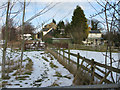
3
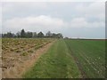
Footpath to Deal Road
This field edge path leads from Mill Lane towards the A258 Road.
Image: © David Anstiss
Taken: 13 Feb 2011
0.06 miles
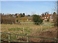
7

Farmland near Worth
The topsoil is very thin, the ploughed up chalk can be seen clearly.
Image: © Nick Smith
Taken: 7 Oct 2007
0.11 miles
9
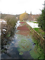
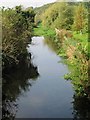
The North Stream, Ham
Some brightly coloured weed partially covering the stream despite the freezing weather.
Image: © Nick Smith
Taken: 15 Feb 2010
0.12 miles