IMAGES TAKEN NEAR TO
Jubilee Road, DEAL, CT14 0DS
Introduction
This page details the photographs taken nearby to Jubilee Road, CT14 0DS by members of the Geograph project.
The Geograph project started in 2005 with the aim of publishing, organising and preserving representative images for every square kilometre of Great Britain, Ireland and the Isle of Man.

There are currently over 7.5m images from over14,400 individuals and you can help contribute to the project by visiting https://www.geograph.org.uk
Image Map
Images are licensed for reuse under creativecommons.org/licenses/by-sa/2.0
Notes
- Clicking on the map will re-center to the selected point.
- The higher the marker number, the further away the image location is from the centre of the postcode.
Image Listing (21 Images Found)
Images are licensed for reuse under creativecommons.org/licenses/by-sa/2.0
Image
Details
Distance
1

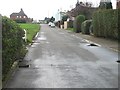
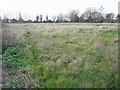
Jubilee Road
A 1km straight road from Worth to the A258.
Image: © Oast House Archive
Taken: 24 Jul 2010
0.03 miles
7
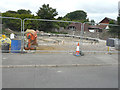
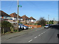
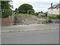
Building site, Jubilee Road
Planning permission has been granted by Dover District Council under application number DOV/16/01317 for the “erection of a pair of semi-detached dwellings and creation of accesses”. The location was described as being land adjacent to 1, Church Farm Cottages (which are visible to the right).
Image: © John Baker
Taken: 16 Jul 2017
0.13 miles
8
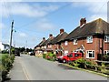
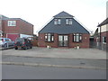
1 & 2, Downs View, Jubilee Road
This pair of semi-detached houses were built on Image
Image: © John Baker
Taken: 20 Jan 2019
0.15 miles
9
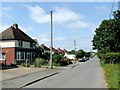
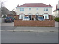
Development land, Jubilee Road
Planning permission has been granted by Dover District Council under application number DOV/16/01119 for the “erection of a 2 semi-detached dwellings and creation of access and parking”. The location was described as being land adjacent to Marshlands (part of its garden wall is visible).
The land is now occupied by Image
Image: © John Baker
Taken: 16 Jul 2017
0.15 miles