IMAGES TAKEN NEAR TO
The Street, DEAL, CT14 0DG
Introduction
This page details the photographs taken nearby to The Street, CT14 0DG by members of the Geograph project.
The Geograph project started in 2005 with the aim of publishing, organising and preserving representative images for every square kilometre of Great Britain, Ireland and the Isle of Man.

There are currently over 7.5m images from over14,400 individuals and you can help contribute to the project by visiting https://www.geograph.org.uk
Image Map
Images are licensed for reuse under creativecommons.org/licenses/by-sa/2.0
Notes
- Clicking on the map will re-center to the selected point.
- The higher the marker number, the further away the image location is from the centre of the postcode.
Image Listing (76 Images Found)
Images are licensed for reuse under creativecommons.org/licenses/by-sa/2.0
Image
Details
Distance
1
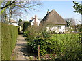
View along path in the village of Worth
The path runs parallel with The Street and ends near Minnis Farm
Image: © Nick Smith
Taken: 20 Mar 2009
0.01 miles
2
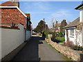
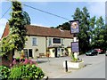
View along path toward The Street, Worth
The path joins The Street nearly opposite the St Crispin Inn.
Image: © Nick Smith
Taken: 20 Mar 2009
0.02 miles

4
Worth County Primary School, The Street
Dover District Council has not raised any objection to planning application number DOV/20/00327 to “demolish existing mobile classroom and construct new extension off the existing school building”. This was Image, after the new extension had been completed.
This view of Image showed the mobile classroom.
Image: © John Baker
Taken: 13 Sep 2020
0.03 miles
5
Worth County Primary School
This was Image, when a new extension was being built.
Image: © John Baker
Taken: 12 Jun 2022
0.03 miles
6

Northbrook House, Minnis Way
Seen from The Street, planning permission has been granted by Dover District Council under application number DOV/12/00912 for the "erection of two single storey side extensions, two pitched roofs over existing garage and associated external alterations (existing conservatory to be demolished)".
Image: © John Baker
Taken: 30 Dec 2012
0.03 miles
7

Northbrook House from The Street
When I photographed the house at the end of 2012, it was half hidden under scaffolding and polythene sheeting Image Now the building work seems to have been just about completed.
Image: © John Baker
Taken: 27 Aug 2013
0.03 miles
9
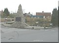
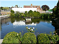
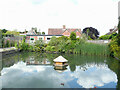
The village pond, Worth
Seen from The Street with the war memorial in the foreground and Worth Primary School across the pond. Nick Smith's picture Image shows the view before the tall fence was erected, possibly on the grounds of health and safety to prevent the children falling into the pond!
Image: © John Baker
Taken: 30 Dec 2012
0.03 miles
10
Northbrook House, Minnis Way
This was Image, during the time that work was being carried out to the house.
Image: © John Baker
Taken: 12 Jun 2022
0.04 miles