IMAGES TAKEN NEAR TO
Ashford Road, CANTERBURY, CT1 3XS
Introduction
This page details the photographs taken nearby to Ashford Road, CT1 3XS by members of the Geograph project.
The Geograph project started in 2005 with the aim of publishing, organising and preserving representative images for every square kilometre of Great Britain, Ireland and the Isle of Man.

There are currently over 7.5m images from over14,400 individuals and you can help contribute to the project by visiting https://www.geograph.org.uk
Image Map
Images are licensed for reuse under creativecommons.org/licenses/by-sa/2.0
Notes
- Clicking on the map will re-center to the selected point.
- The higher the marker number, the further away the image location is from the centre of the postcode.
Image Listing (29 Images Found)
Images are licensed for reuse under creativecommons.org/licenses/by-sa/2.0
Image
Details
Distance
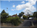
2

A28 Ashford Road
Heading into Canterbury.
Image: © Robin Webster
Taken: 8 Feb 2018
0.04 miles
5
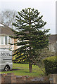
Monkey Puzzle Tree, Ashford Road, Canterbury
Image: © Julian P Guffogg
Taken: 30 Mar 2013
0.05 miles
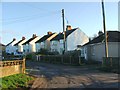
6

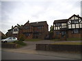
New houses on Thanington Road, Thanington
The second two have been up for around a year.
Image: © David Howard
Taken: 31 Jul 2016
0.05 miles
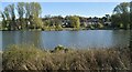
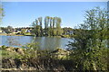
7
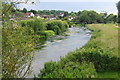
The Great Stour near Thanington
Looking upstream. The houses are the western end of Thanington.
Image: © Bill Boaden
Taken: 25 Jun 2012
0.10 miles