IMAGES TAKEN NEAR TO
Ashenden Close, CANTERBURY, CT1 3XL
Introduction
This page details the photographs taken nearby to Ashenden Close, CT1 3XL by members of the Geograph project.
The Geograph project started in 2005 with the aim of publishing, organising and preserving representative images for every square kilometre of Great Britain, Ireland and the Isle of Man.

There are currently over 7.5m images from over14,400 individuals and you can help contribute to the project by visiting https://www.geograph.org.uk
Image Map
Images are licensed for reuse under creativecommons.org/licenses/by-sa/2.0
Notes
- Clicking on the map will re-center to the selected point.
- The higher the marker number, the further away the image location is from the centre of the postcode.
Image Listing (65 Images Found)
Images are licensed for reuse under creativecommons.org/licenses/by-sa/2.0
Image
Details
Distance
8
Cockering Road development
This development off Cockering Road for which planning permission has been granted by Canterbury City Council, will be a residential nursing and respite care home, Lark View Care Home, due to open early in 2023.
Image: © John Baker
Taken: 16 Jan 2022
0.16 miles
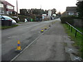
9
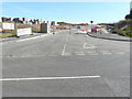
Entrance to Saxon Fields
This is the name of a development off Cockering Road for which planning permission has been granted by Canterbury City Council under application number CA//15/01479.
Saxon Fields is an “outline application for a comprehensive mixed use development comprising: up to 750 residential units, in a mix of sizes, types and tenures; up to 4,000 m2 (gross internal floorspace) of Class B1 floorspace; up to 1,000 m2 (gross internal floorspace) of Class A1 to A5 uses.
A primary school.
Up to 5,000 m2 (gross internal area) of residential institutions, including a building for the Pilgrims Hospices with up to 30 beds and a 60 bed Nursing Home (Class C2).
Up to 2,000 m2 (gross internal area of Community and Leisure Uses (Classes D1 and D2).
Provision of local recycling facilities; provision of areas of formal and informal open space; installation of utilities infrastructure to serve the development, including flood attenuation works, surface water attenuation, water supply, waste water facilities, gas supply, electricity supply (including substations), telecommunications infrastructure and renewable energy.
Transport infrastructure, including an extended westbound slip road on the A2, accesses onto Cockering Road plus a network of internal roads, footpaths and cycle routes.
New planting and landscaping, both within the proposed development and on its boundaries as well as ecological enhancement works; and associated groundworks. all matters except for access are reserved”.
This is another Image
Image: © John Baker
Taken: 15 Sep 2019
0.16 miles
10
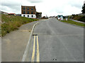
Saxon Fields
This is the name of a development off Cockering Road for which planning permission has been granted by Canterbury City Council under application number CA//15/01479.
There are two entrances into the development; this has been named Broadbank Way.
Image: © John Baker
Taken: 29 Aug 2021
0.17 miles