IMAGES TAKEN NEAR TO
Priory Of St. Jacobs, CANTERBURY, CT1 3TR
Introduction
This page details the photographs taken nearby to Priory Of St. Jacobs, CT1 3TR by members of the Geograph project.
The Geograph project started in 2005 with the aim of publishing, organising and preserving representative images for every square kilometre of Great Britain, Ireland and the Isle of Man.

There are currently over 7.5m images from over14,400 individuals and you can help contribute to the project by visiting https://www.geograph.org.uk
Image Map
Images are licensed for reuse under creativecommons.org/licenses/by-sa/2.0
Notes
- Clicking on the map will re-center to the selected point.
- The higher the marker number, the further away the image location is from the centre of the postcode.
Image Listing (123 Images Found)
Images are licensed for reuse under creativecommons.org/licenses/by-sa/2.0
Image
Details
Distance
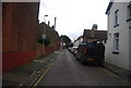
3
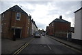
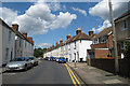
Hollow Lane, Canterbury
Towards the junction with the A28, Wincheap.
Image: © Robin Webster
Taken: 13 Oct 2018
0.03 miles
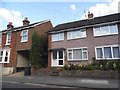
4
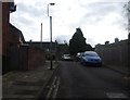
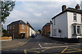
Hollow Lane
A street of houses in South West Canterbury.
Image: © DS Pugh
Taken: 20 Aug 2019
0.03 miles
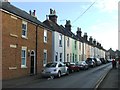
5
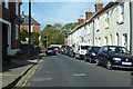
Terraced Housing on Hollow Lane, Canterbury, Kent
Image: © Oast House Archive
Taken: 15 Aug 2008
0.03 miles
6
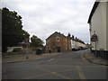
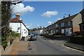
Hollow Lane, Wincheap
This is its northern end where it meets the A28.
Image: © Bill Boaden
Taken: 25 Jun 2012
0.03 miles