IMAGES TAKEN NEAR TO
The Foreland, CANTERBURY, CT1 3NS
Introduction
This page details the photographs taken nearby to The Foreland, CT1 3NS by members of the Geograph project.
The Geograph project started in 2005 with the aim of publishing, organising and preserving representative images for every square kilometre of Great Britain, Ireland and the Isle of Man.

There are currently over 7.5m images from over14,400 individuals and you can help contribute to the project by visiting https://www.geograph.org.uk
Image Map (Loading...)


Getting Data...Please wait
Leaflet Map data © OpenStreetMap
Images are licensed for reuse under creativecommons.org/licenses/by-sa/2.0
Notes
- Clicking on the map will re-center to the selected point.
- The higher the marker number, the further away the image location is from the centre of the postcode.
Image Listing (18 Images Found)
Images are licensed for reuse under creativecommons.org/licenses/by-sa/2.0
Image
Details
Distance
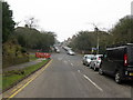
3
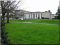
Simon Langton School for girls, Old Dover Road
Image: © Nick Smith
Taken: 18 Feb 2007
0.16 miles
5
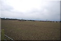
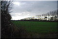
Fallow field
On the OS map this area is shown as orchards.
Image: © N Chadwick
Taken: 13 Jan 2013
0.17 miles
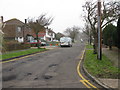
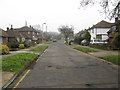
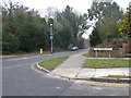
6
Junction of The Foreland with Nackington Road
Image: © Nick Smith
Taken: 18 Feb 2010
0.18 miles
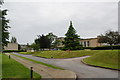
7
Junction of The Forstal with Nackington Road
Image: © Nick Smith
Taken: 18 Feb 2010
0.19 miles