IMAGES TAKEN NEAR TO
Ethelbert Road, CANTERBURY, CT1 3ND
Introduction
This page details the photographs taken nearby to Ethelbert Road, CT1 3ND by members of the Geograph project.
The Geograph project started in 2005 with the aim of publishing, organising and preserving representative images for every square kilometre of Great Britain, Ireland and the Isle of Man.

There are currently over 7.5m images from over14,400 individuals and you can help contribute to the project by visiting https://www.geograph.org.uk
Image Map
Images are licensed for reuse under creativecommons.org/licenses/by-sa/2.0
Notes
- Clicking on the map will re-center to the selected point.
- The higher the marker number, the further away the image location is from the centre of the postcode.
Image Listing (68 Images Found)
Images are licensed for reuse under creativecommons.org/licenses/by-sa/2.0
Image
Details
Distance
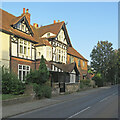
1
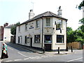
Canterbury: up Old Dover Road
A picture taken against the light on a sunny early-September morning.
Image: © John Sutton
Taken: 11 Sep 2023
0.06 miles
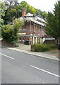
2
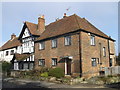
No.81 Old Dover Road, Canterbury
A Grade II listed house, part of a group of listed houses on the road.
This one is also called 'The Oast'.
See http://www.britishlistedbuildings.co.uk/en-440162-81a-old-dover-road-kent for more details about the building.
Image: © David Anstiss
Taken: 17 Feb 2013
0.07 miles
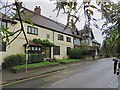
4
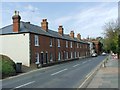
Canterbury: The Old Forge
Though dated 1694, most of this heavily-restored house looks Victorian. The red-brick house adjoining is also Grade II listed, but the listing does not date it.
Image: © John Sutton
Taken: 9 Sep 2023
0.07 miles
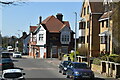
5
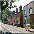
Old Dover Road, Canterbury
The houses seen here near the junction with Randolph Close: Sundial House (the yellow one) and the Old Forge, as well as the end house of the row (No 81A), are all Grade II listed.
Image: © Paul Harrop
Taken: 8 Sep 2017
0.08 miles
6
Ongoing alterations to 78, Old Dover Road
Planning permission has been granted by Canterbury City Council under application number CA//14/01981 for the “demolition of garage, erection of two and one-storey extension at side, extension of second floor rear dormer window”.
Image: © John Baker
Taken: 10 Jul 2016
0.11 miles
8
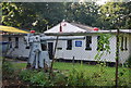
Sea cadets hut & gun, Puckle Lane
This looks very much like a deck gun from a submarine.
Image: © N Chadwick
Taken: 27 Sep 2008
0.15 miles
9
Derelict building beside Abbots Barton Walk
The path runs between New Dover Road and Old Dover Road. Abbot’s Barton was the leased, private residence of Francis Bennett-Goldney, Mayor of Canterbury from 1905-10 and Member of Parliament from 1917-18 http://www.machadoink.com/Francis%20Bennett%20Goldney.htm
This building was demolished and replaced by one of a similar construction, which can be seen when Image
Image: © John Baker
Taken: 2 Dec 2012
0.16 miles