IMAGES TAKEN NEAR TO
South Canterbury Road, CANTERBURY, CT1 3LJ
Introduction
This page details the photographs taken nearby to South Canterbury Road, CT1 3LJ by members of the Geograph project.
The Geograph project started in 2005 with the aim of publishing, organising and preserving representative images for every square kilometre of Great Britain, Ireland and the Isle of Man.

There are currently over 7.5m images from over14,400 individuals and you can help contribute to the project by visiting https://www.geograph.org.uk
Image Map
Images are licensed for reuse under creativecommons.org/licenses/by-sa/2.0
Notes
- Clicking on the map will re-center to the selected point.
- The higher the marker number, the further away the image location is from the centre of the postcode.
Image Listing (28 Images Found)
Images are licensed for reuse under creativecommons.org/licenses/by-sa/2.0
Image
Details
Distance
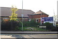
1

Canterbury Bowling Club
The club was founded in the reign of Queen Victoria. This is the club's new site, in South Canterbury Road. It boasts two well-kept greens.
Image: © Philip Talmage
Taken: 10 Aug 2005
0.07 miles
2
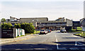
Site of former Canterbury South station, now with Kent & Canterbury Hospital built over it, 1990
View SE from South Canterbury Road. The station had been on the ex-SE&CR (Canterbury West) Harbledown Junction (to left) - (to right) Cheriton Junction (Shorncliffe), the Elham Valley line, which was closed (Canterbury - Lyminge) to passengers 1/12/40 (to goods 1/10/47), having been taken over by the War Department in 1940, but provided a passenger service Lyminge - Shorncliffe until 1947.
Image: © Ben Brooksbank
Taken: 8 Oct 1990
0.09 miles
3
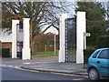
Entrance to Kent and Canterbury Hospital
From Ethelbert Road, leads to the oldest building on the site.
Also has footpath to Nackington Road and Simon Langton Girls' School.
Image: © David Anstiss
Taken: 15 Nov 2008
0.12 miles
4
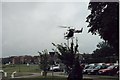
Helicopter bringing patient to the Kent and Canterbury Hospital
Image: © Elliott Simpson
Taken: Unknown
0.12 miles
5
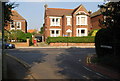
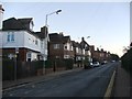
The end of Stuppington Lane, Canterbury
Outer suburbs of Canterbury.
Image: © N Chadwick
Taken: 27 Sep 2008
0.14 miles
6
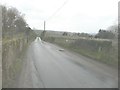
Parapets of a bridge, Stuppington Lane
The bridge once carried the road over the Elham Valley Railway, which closed in 1948. There is a deep, overgrown cutting to the left of the bridge, but this has been infilled to the right of it.
Image: © John Baker
Taken: 10 Mar 2013
0.16 miles
8
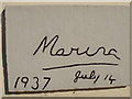
Kent and Canterbury Hospital
On the front wall of the original hospital building there is this unusual etched stone, which indicates (I assume) the opening of the hospital in 1937 by Princess Marina of Kent.
Image: © Andy Parrett
Taken: 31 May 2009
0.20 miles
9
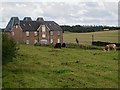
By Stuppington Lane, Canterbury
Grazing land to the south of the city; traffic on the A2 Canterbury bypass can be seen over to the right.
Image: © Paul Harrop
Taken: 11 Sep 2017
0.20 miles
10
New housing development on South Canterbury Rd.
Redevelopment on the site of an old chapel
Image: © N Chadwick
Taken: 27 Sep 2008
0.21 miles