IMAGES TAKEN NEAR TO
Old Dover Road, CANTERBURY, CT1 3JQ
Introduction
This page details the photographs taken nearby to Old Dover Road, CT1 3JQ by members of the Geograph project.
The Geograph project started in 2005 with the aim of publishing, organising and preserving representative images for every square kilometre of Great Britain, Ireland and the Isle of Man.

There are currently over 7.5m images from over14,400 individuals and you can help contribute to the project by visiting https://www.geograph.org.uk
Image Map
Images are licensed for reuse under creativecommons.org/licenses/by-sa/2.0
Notes
- Clicking on the map will re-center to the selected point.
- The higher the marker number, the further away the image location is from the centre of the postcode.
Image Listing (1048 Images Found)
Images are licensed for reuse under creativecommons.org/licenses/by-sa/2.0
Image
Details
Distance
1
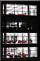
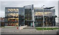
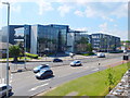
Offices at Rhodaus Town
Modern open plan offices.
Image: © Oast House Archive
Taken: 18 Dec 2011
0.02 miles
3
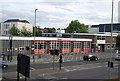
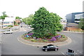
Riding Gate roundabout, Canterbury
Riding Gate roundabout, where St George's Place meets the inner ring road, seen from the city walls.
Image: © Richard Vince
Taken: 25 Aug 2012
0.03 miles
6
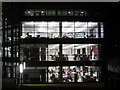
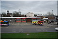
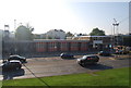
Offices at Rhodaus Town
Modern open plan offices.
Image: © Oast House Archive
Taken: 18 Dec 2011
0.04 miles