IMAGES TAKEN NEAR TO
Nunnery Fields, CANTERBURY, CT1 3JN
Introduction
This page details the photographs taken nearby to Nunnery Fields, CT1 3JN by members of the Geograph project.
The Geograph project started in 2005 with the aim of publishing, organising and preserving representative images for every square kilometre of Great Britain, Ireland and the Isle of Man.

There are currently over 7.5m images from over14,400 individuals and you can help contribute to the project by visiting https://www.geograph.org.uk
Image Map
Images are licensed for reuse under creativecommons.org/licenses/by-sa/2.0
Notes
- Clicking on the map will re-center to the selected point.
- The higher the marker number, the further away the image location is from the centre of the postcode.
Image Listing (357 Images Found)
Images are licensed for reuse under creativecommons.org/licenses/by-sa/2.0
Image
Details
Distance
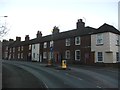
1
![Canterbury houses [140]](https://s0.geograph.org.uk/geophotos/07/09/56/7095656_62bcf3c6_120x120.jpg)
Canterbury houses [140]
Numbers 5 to 14 Nunnery Fields are a terrace of 10 houses dated 1827 with a later extension. Constructed of red brick, with some stucco and some weatherboarding, under a tile roof. Listed, grade II, with details at: https://historicengland.org.uk/listing/the-list/list-entry/1241182
Canterbury is a small historic city on the River Stour in Kent, some 54 miles southeast of London. Occupied since prehistoric times, it became an important Roman city. In 672, the see of Canterbury gained authority over the entire English Church. After the murder of Archbishop Thomas Becket at the cathedral in 1170, pilgrims from all parts of Christendom came to visit his shrine until the Dissolution. Today, Canterbury is a popular tourist destination and one of the most-visited cities in the United Kingdom. The city has a substantial student population, with four university campuses.
Image: © Michael Dibb
Taken: 7 Sep 2021
0.00 miles
4
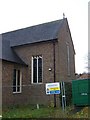
St Mary Bredin under Construction
Canterbury Church on junction of Old Dover Road and Nunnery Fields.
Photo taken on Nunnery Fields Road. Construction Project includes upgrading the Kendal Hall and the Church/Church Centre.
About the project see link http://www.smb.org.uk
Image: © David Anstiss
Taken: 16 Nov 2008
0.02 miles
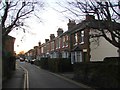
5
![Canterbury buildings [97]](https://s2.geograph.org.uk/geophotos/07/09/56/7095654_59003dec_120x120.jpg)
Canterbury buildings [97]
Numbers 3 and 4 Nunnery Fields are an 18th century industrial building. Constructed of painted brick, part weatherboarded, all under a tile roof with one dormer and hoist opening. Listed, grade II, with details at: https://historicengland.org.uk/listing/the-list/list-entry/1241141
Canterbury is a small historic city on the River Stour in Kent, some 54 miles southeast of London. Occupied since prehistoric times, it became an important Roman city. In 672, the see of Canterbury gained authority over the entire English Church. After the murder of Archbishop Thomas Becket at the cathedral in 1170, pilgrims from all parts of Christendom came to visit his shrine until the Dissolution. Today, Canterbury is a popular tourist destination and one of the most-visited cities in the United Kingdom. The city has a substantial student population, with four university campuses.
Image: © Michael Dibb
Taken: 7 Sep 2021
0.03 miles
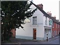
7
The Two Doves Public House, Canterbury
On junction of Nunnery Fields and Caledon Terrace.
Near the roadbridge over the Railway.
Image: © David Anstiss
Taken: 16 Nov 2008
0.04 miles
8
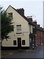
![Canterbury houses [145]](https://s0.geograph.org.uk/geophotos/07/09/66/7096636_314d3cd3_120x120.jpg)
Canterbury houses [145]
Numbers 48 and 50 Old Dover Road and number 1 Nunnery Fields were built in the early 19th century. Constructed of stuccoed brick under a tile roof. Listed, grade II, with details at: https://historicengland.org.uk/listing/the-list/list-entry/1260564
Canterbury is a small historic city on the River Stour in Kent, some 54 miles southeast of London. Occupied since prehistoric times, it became an important Roman city. In 672, the see of Canterbury gained authority over the entire English Church. After the murder of Archbishop Thomas Becket at the cathedral in 1170, pilgrims from all parts of Christendom came to visit his shrine until the Dissolution. Today, Canterbury is a popular tourist destination and one of the most-visited cities in the United Kingdom. The city has a substantial student population, with four university campuses.
Image: © Michael Dibb
Taken: 7 Sep 2021
0.05 miles

10
![Canterbury houses [144]](https://s3.geograph.org.uk/geophotos/07/09/66/7096635_ef1bdddb_120x120.jpg)
Canterbury houses [144]
Number 46 Old Dover Road was built in the early 19th century. Constructed of stuccoed brick under a tile roof. Listed, grade II, with details at: https://historicengland.org.uk/listing/the-list/list-entry/1241199
Canterbury is a small historic city on the River Stour in Kent, some 54 miles southeast of London. Occupied since prehistoric times, it became an important Roman city. In 672, the see of Canterbury gained authority over the entire English Church. After the murder of Archbishop Thomas Becket at the cathedral in 1170, pilgrims from all parts of Christendom came to visit his shrine until the Dissolution. Today, Canterbury is a popular tourist destination and one of the most-visited cities in the United Kingdom. The city has a substantial student population, with four university campuses.
Image: © Michael Dibb
Taken: 7 Sep 2021
0.05 miles