IMAGES TAKEN NEAR TO
Old Dover Road, CANTERBURY, CT1 3ES
Introduction
This page details the photographs taken nearby to Old Dover Road, CT1 3ES by members of the Geograph project.
The Geograph project started in 2005 with the aim of publishing, organising and preserving representative images for every square kilometre of Great Britain, Ireland and the Isle of Man.

There are currently over 7.5m images from over14,400 individuals and you can help contribute to the project by visiting https://www.geograph.org.uk
Image Map
Images are licensed for reuse under creativecommons.org/licenses/by-sa/2.0
Notes
- Clicking on the map will re-center to the selected point.
- The higher the marker number, the further away the image location is from the centre of the postcode.
Image Listing (13 Images Found)
Images are licensed for reuse under creativecommons.org/licenses/by-sa/2.0
Image
Details
Distance
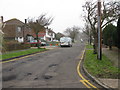
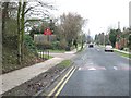
2
Simon Langton School for girls, Old Dover Road
Image: © Nick Smith
Taken: 18 Feb 2007
0.08 miles
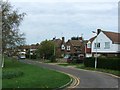
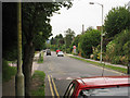
5
Old Dover Road and entrance to St Anselm's School
Image: © Nick Smith
Taken: 18 Feb 2007
0.16 miles
6
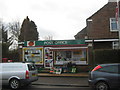
Barton Road Post Office
On Barton Road, close to the A2050 New Dover Road.
Image: © David Anstiss
Taken: 26 Mar 2010
0.21 miles
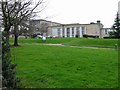
7
Barton Evangelical Church
On Barton Road.
Image: © David Anstiss
Taken: 26 Mar 2010
0.21 miles
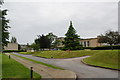
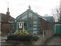
8
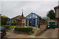
Barton Evangelical Church
A church on a residential estate. It now meets in larger rented premises, but this site is retained as an office.
Image: © Bill Boaden
Taken: 27 Jun 2012
0.22 miles
9
Canterbury
Canterbury, New Dover Road park & ride car park.
Image: © Helmut Zozmann
Taken: 29 Jul 2012
0.24 miles