IMAGES TAKEN NEAR TO
Old Dover Road, CANTERBURY, CT1 3AY
Introduction
This page details the photographs taken nearby to Old Dover Road, CT1 3AY by members of the Geograph project.
The Geograph project started in 2005 with the aim of publishing, organising and preserving representative images for every square kilometre of Great Britain, Ireland and the Isle of Man.

There are currently over 7.5m images from over14,400 individuals and you can help contribute to the project by visiting https://www.geograph.org.uk
Image Map
Images are licensed for reuse under creativecommons.org/licenses/by-sa/2.0
Notes
- Clicking on the map will re-center to the selected point.
- The higher the marker number, the further away the image location is from the centre of the postcode.
Image Listing (102 Images Found)
Images are licensed for reuse under creativecommons.org/licenses/by-sa/2.0
Image
Details
Distance
1
Ongoing alterations to 78, Old Dover Road
Planning permission has been granted by Canterbury City Council under application number CA//14/01981 for the “demolition of garage, erection of two and one-storey extension at side, extension of second floor rear dormer window”.
Image: © John Baker
Taken: 10 Jul 2016
0.01 miles
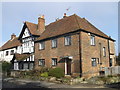
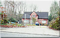
2
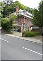
Old Dover Road, Canterbury
The houses seen here near the junction with Randolph Close: Sundial House (the yellow one) and the Old Forge, as well as the end house of the row (No 81A), are all Grade II listed.
Image: © Paul Harrop
Taken: 8 Sep 2017
0.05 miles
4
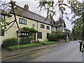
Canterbury: The Old Forge
Though dated 1694, most of this heavily-restored house looks Victorian. The red-brick house adjoining is also Grade II listed, but the listing does not date it.
Image: © John Sutton
Taken: 9 Sep 2023
0.06 miles
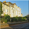
5
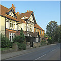
No.81 Old Dover Road, Canterbury
A Grade II listed house, part of a group of listed houses on the road.
This one is also called 'The Oast'.
See http://www.britishlistedbuildings.co.uk/en-440162-81a-old-dover-road-kent for more details about the building.
Image: © David Anstiss
Taken: 17 Feb 2013
0.06 miles
7
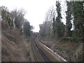
Railway Line to Canterbury East
As seen from the A2050 Old Dover Road.
This line leads from Dover (via various stations including Bekesbourne) towards Canterbury East.
In the background is Nunnery Fields roadbridge.
Image: © David Anstiss
Taken: 21 Feb 2013
0.07 miles
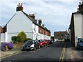
8
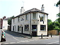
Canterbury: bright stucco on Old Dover Road
Photographed on the evening of the hottest day of the year to date, at the end of a very hot week at the beginning of September 2023.
Image: © John Sutton
Taken: 9 Sep 2023
0.08 miles
9

68, Old Dover Road
As the ‘to let’ board indicates, this is student accommodation.
Image: © John Baker
Taken: 10 Jul 2016
0.09 miles
10
68, Old Dover Road
Planning permission has been granted by Canterbury City Council under application number CA/20/02186 for a "three-storey building with a basement, comprising 27 student apartments (including warden's accommodation) with communal facilities including cycle and refuse storage, amenity areas and three 'operational' parking spaces for service/maintenance vehicles, following demolition of the existing dwelling and a garage".
Taken during a photographic outing on Christmas Day afternoon.
Image: © John Baker
Taken: 25 Dec 2022
0.09 miles