IMAGES TAKEN NEAR TO
Ramsgate Road, SANDWICH, CT13 9ST
Introduction
This page details the photographs taken nearby to Ramsgate Road, CT13 9ST by members of the Geograph project.
The Geograph project started in 2005 with the aim of publishing, organising and preserving representative images for every square kilometre of Great Britain, Ireland and the Isle of Man.

There are currently over 7.5m images from over14,400 individuals and you can help contribute to the project by visiting https://www.geograph.org.uk
Image Map
Images are licensed for reuse under creativecommons.org/licenses/by-sa/2.0
Notes
- Clicking on the map will re-center to the selected point.
- The higher the marker number, the further away the image location is from the centre of the postcode.
Image Listing (35 Images Found)
Images are licensed for reuse under creativecommons.org/licenses/by-sa/2.0
Image
Details
Distance
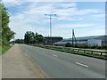
2

Old Milestone by Ramsgate Road, Sandwich parish
Stone post (plates lost) by the UC road (was A256), in parish of SANDWICH (DOVER District), Ramsgate Road, near Stonar Cut, on the verge, back to wire security fence, on West side of road. Ramsgate marker, erected by the Sandwich, Margate & Ramsgate turnpike trust in the 19th century.
Inscription once read:-
: (5 / MILES / TO / RAMSGATE / 7 / MILES / TO / MARGATE) : : (2 / MILES / TO / SANDWICH) :
Kent HER.
HER Number: TR 36 SW 207 https://www.heritagegateway.org.uk/Gateway/Results_Single.aspx?uid=MKE78209&resourceID=1005
Milestone Society National ID: KE_RGSW05.
Image: © B Jones
Taken: 12 Feb 2009
0.03 miles

5

Walking the Saxon Shore Way
People descending on the nearest spot to watch the demolition of the Richborough towers.
Image: © Oast House Archive
Taken: 11 Mar 2012
0.06 miles
6
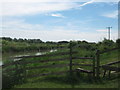
Stile on the Saxon Shore Way beside River Stour
The long distance path leads beside the river, from Plucks Gutter towards Sandwich.
Image: © David Anstiss
Taken: 30 May 2011
0.07 miles
7
Boats on the River Stour
The nearest the boats were allowed along the river whilst it was closed awaiting the demolition of the towers.
Image: © Oast House Archive
Taken: 11 Mar 2012
0.08 miles

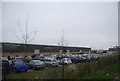
9
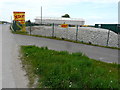
A SKIP 4 U, Ramsgate Road
A Skip 4 U have been independently trading from their site in Sandwich since 1984 and employ a force of local drivers. Their fleet of specially designed lorries [also] come in many sizes – they even have ones that are compact and perfect for those hard to access sites and driveways. They can also lift and tip over medium size walls.
All of the waste materials are taken back to their recycling centre in Sandwich where it all gets hand sorted into the different waste categories to be dealt with and recycled appropriately https://www.a-skip4u.com/about-us
Note: the large, rectangular shed in the background has received a thorough refurbishment. It used to be a very decrepit Image
Image: © John Baker
Taken: 2 May 2019
0.09 miles
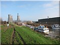
10

Stonar Cut
A short channel, which cuts off a large meander on the River Stour.
Image: © N Chadwick
Taken: 5 Apr 2012
0.09 miles