IMAGES TAKEN NEAR TO
Bridge Close, SANDWICH, CT13 9QG
Introduction
This page details the photographs taken nearby to Bridge Close, CT13 9QG by members of the Geograph project.
The Geograph project started in 2005 with the aim of publishing, organising and preserving representative images for every square kilometre of Great Britain, Ireland and the Isle of Man.

There are currently over 7.5m images from over14,400 individuals and you can help contribute to the project by visiting https://www.geograph.org.uk
Image Map
Images are licensed for reuse under creativecommons.org/licenses/by-sa/2.0
Notes
- Clicking on the map will re-center to the selected point.
- The higher the marker number, the further away the image location is from the centre of the postcode.
Image Listing (458 Images Found)
Images are licensed for reuse under creativecommons.org/licenses/by-sa/2.0
Image
Details
Distance
1
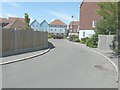
Looking west-northwest along Bridge Close
Towards some of the houses that comprise a new housing development, still under construction, known as The Knots of Willowbank. The development is a collection of one and two bedroom apartments and three and four bedroom homes http://quaysidehomes.co.uk/current-developments/knots
Image: © John Baker
Taken: 2 Jul 2014
0.02 miles
2
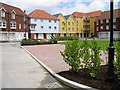
Willowbank, a new housing development
A new development comprising a collection of two bedroom apartments and two, three and four bedroom homes on the banks of the River Stour.
Image: © Nick Smith
Taken: 1 Jul 2007
0.03 miles
3
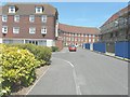
The Knots of Willowbank
These are some of the houses that comprise a new housing development, still under construction, which is a collection of one and two bedroom apartments and three and four bedroom homes. Usefully the link gives the numbers of the houses, so I think the curving block contains numbers 51 to 58, while the house, at right angles to it, is number 50 http://quaysidehomes.co.uk/current-developments/knots
Image: © John Baker
Taken: 2 Jul 2014
0.05 miles
5
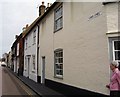
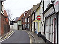
Fisher Street
The right-hand side of Fisher Street looking south.
Image: © Malcolm Spicer
Taken: 25 Apr 2006
0.06 miles
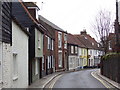
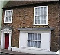
6
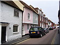
Fisher Street
The left-hand side of Fisher Street looking south.
Image: © Malcolm Spicer
Taken: 25 Apr 2006
0.06 miles