IMAGES TAKEN NEAR TO
Princes Drive, SANDWICH, CT13 9PR
Introduction
This page details the photographs taken nearby to Princes Drive, CT13 9PR by members of the Geograph project.
The Geograph project started in 2005 with the aim of publishing, organising and preserving representative images for every square kilometre of Great Britain, Ireland and the Isle of Man.

There are currently over 7.5m images from over14,400 individuals and you can help contribute to the project by visiting https://www.geograph.org.uk
Image Map
Images are licensed for reuse under creativecommons.org/licenses/by-sa/2.0
Notes
- Clicking on the map will re-center to the selected point.
- The higher the marker number, the further away the image location is from the centre of the postcode.
Image Listing (86 Images Found)
Images are licensed for reuse under creativecommons.org/licenses/by-sa/2.0
Image
Details
Distance
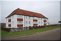
1
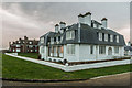
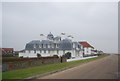
Whitehall and The Dunes
Large houses on the Sandwich Bay Estate.
Image: © Ian Capper
Taken: 25 Jan 2014
0.01 miles
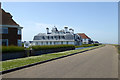
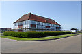
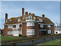
3
Whitehall
Large house on the Sandwich Bay Estate, now subdivided into flats.
Image: © Ian Capper
Taken: 25 Jan 2014
0.01 miles
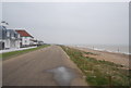
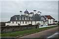
6
The Dunes, Sandwich Bay Estate
On the corner of Princes Drive (in front) and Shawdon Avenue (on the right).
Part of the private estate.
Image: © David Anstiss
Taken: 10 Apr 2011
0.02 miles