IMAGES TAKEN NEAR TO
St. Georges Road, SANDWICH, CT13 9JT
Introduction
This page details the photographs taken nearby to St. Georges Road, CT13 9JT by members of the Geograph project.
The Geograph project started in 2005 with the aim of publishing, organising and preserving representative images for every square kilometre of Great Britain, Ireland and the Isle of Man.

There are currently over 7.5m images from over14,400 individuals and you can help contribute to the project by visiting https://www.geograph.org.uk
Image Map
Images are licensed for reuse under creativecommons.org/licenses/by-sa/2.0
Notes
- Clicking on the map will re-center to the selected point.
- The higher the marker number, the further away the image location is from the centre of the postcode.
Image Listing (375 Images Found)
Images are licensed for reuse under creativecommons.org/licenses/by-sa/2.0
Image
Details
Distance
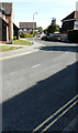
1
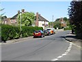
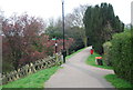
View along St George's Road from Delfside
Image: © Nick Smith
Taken: 20 Apr 2007
0.05 miles
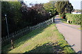
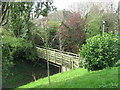
3
Footbridge over the town ditch
This photo is taken from the Mill Wall (line of the old town boundary wall), looking outwards over the ditch that formed part of the defences. A wooden footbridge approached by steps now crosses it on the way to the railway station.
See also Image taken almost exactly a year earlier.
Image: © Stephen Craven
Taken: 15 Apr 2012
0.05 miles
4
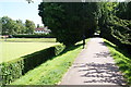
The town walls, Sandwich
A path is now able to make use of the route of part of the old town walls.
Image: © Bill Boaden
Taken: 29 Jun 2012
0.05 miles
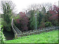
7
Footbridge beside Mill Wall
As seen from Mill Wall (a defensive earth bank wall and ditch around the old part of the town of Sandwich). The bridge leads to St. George's Road.
Image: © David Anstiss
Taken: 10 Apr 2011
0.06 miles
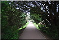
8
View along St George's Road
The entrance to St Andrew's Lees is on the left
Image: © Nick Smith
Taken: 4 Apr 2009
0.06 miles
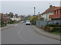
9
Delfside
The road leads to the railway station and the double yellow lines indicate where parking is not permitted. However, parking is permitted in a number of designated bays from Monday to Saturday, between 8:30 am and 5: 30 pm for 2 hours with no return allowed within 4 hours. There are a couple of cars, just beyond the lamppost, using one of these parking bays.
Image: © John Baker
Taken: 22 Jul 2020
0.07 miles
10

View from Mill Wall, Sandwich
Looking across the bowling green to the tower of St. Clement's Church, a Grade I listed building in Knightrider Street.
Image: © pam fray
Taken: 23 Sep 2021
0.07 miles