IMAGES TAKEN NEAR TO
St. Georges Road, SANDWICH, CT13 9JR
Introduction
This page details the photographs taken nearby to St. Georges Road, CT13 9JR by members of the Geograph project.
The Geograph project started in 2005 with the aim of publishing, organising and preserving representative images for every square kilometre of Great Britain, Ireland and the Isle of Man.

There are currently over 7.5m images from over14,400 individuals and you can help contribute to the project by visiting https://www.geograph.org.uk
Image Map (Loading...)


Getting Data...Please wait
Leaflet Map data © OpenStreetMap
Images are licensed for reuse under creativecommons.org/licenses/by-sa/2.0
Notes
- Clicking on the map will re-center to the selected point.
- The higher the marker number, the further away the image location is from the centre of the postcode.
Image Listing (318 Images Found)
Images are licensed for reuse under creativecommons.org/licenses/by-sa/2.0
Image
Details
Distance
1
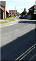
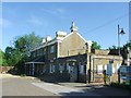
Delfside
The road leads to the railway station and the double yellow lines indicate where parking is not permitted. However, parking is permitted in a number of designated bays from Monday to Saturday, between 8:30 am and 5: 30 pm for 2 hours with no return allowed within 4 hours. There are a couple of cars, just beyond the lamppost, using one of these parking bays.
Image: © John Baker
Taken: 22 Jul 2020
0.03 miles
3
Railway line to Sandwich Station
As seen from Image
Image: © David Anstiss
Taken: 13 Feb 2011
0.06 miles

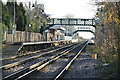
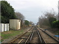
9
Sandwich station from level crossing
The railway between Ramsgate and Sandwich was opened on 1st July 1846. This was extended to terminate at Deal on 1st July 1847. The line was extended on to Dover on 15th June 1881 and the line was electrified on 18th June 1962. On 5th September 2011 a direct high speed services to St Pancras International was introduced so Javelins can be seen travelling across the flat marshland landscape here. This looks from the level crossing where Dover Road meets New Street towards Sandwich station.
Image: © Marathon
Taken: 25 Jan 2014
0.07 miles
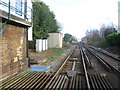
10
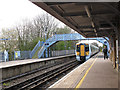
The London train at Sandwich
A class 375 Electrostar unit enters the southbound platform on the 17.02 service to Charing Cross. It is passing under the footbridge which is grade II listed (List Entry Number 1249732) and dates from the opening of the station in 1847.
Image: © Stephen Craven
Taken: 15 Apr 2012
0.07 miles