IMAGES TAKEN NEAR TO
Ash Road, SANDWICH, CT13 9JA
Introduction
This page details the photographs taken nearby to Ash Road, CT13 9JA by members of the Geograph project.
The Geograph project started in 2005 with the aim of publishing, organising and preserving representative images for every square kilometre of Great Britain, Ireland and the Isle of Man.

There are currently over 7.5m images from over14,400 individuals and you can help contribute to the project by visiting https://www.geograph.org.uk
Image Map
Images are licensed for reuse under creativecommons.org/licenses/by-sa/2.0
Notes
- Clicking on the map will re-center to the selected point.
- The higher the marker number, the further away the image location is from the centre of the postcode.
Image Listing (99 Images Found)
Images are licensed for reuse under creativecommons.org/licenses/by-sa/2.0
Image
Details
Distance
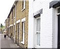
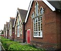
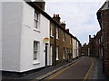
2
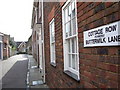
Cottage Row
Looking down Cottage Row from Strand Street. Sandwich Infant School is at the bottom of the road.
Image: © Malcolm Spicer
Taken: 27 Apr 2006
0.02 miles
3
Paradise Row
Paradise Row looking north from its junction with School Road.
Image: © Malcolm Spicer
Taken: 27 Apr 2006
0.02 miles
4
Paradise Row
Paradise Row looking south from its junction with School Road.
Image: © Malcolm Spicer
Taken: 27 Apr 2006
0.02 miles
6
Strand Street
Strand Street looking northwest from its junction with Church Street St. Marys.
Image: © Malcolm Spicer
Taken: 27 Apr 2006
0.02 miles
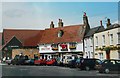
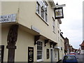
7
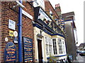
The New Inn
The New Inn in Delf Street.
Image: © Malcolm Spicer
Taken: 27 Apr 2006
0.02 miles
9
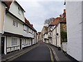
Church Street St. Marys
St Mary's Church can be seen at the end of the street.
Image: © Malcolm Spicer
Taken: 27 Apr 2006
0.02 miles