IMAGES TAKEN NEAR TO
Stour Court, SANDWICH, CT13 9FY
Introduction
This page details the photographs taken nearby to Stour Court, CT13 9FY by members of the Geograph project.
The Geograph project started in 2005 with the aim of publishing, organising and preserving representative images for every square kilometre of Great Britain, Ireland and the Isle of Man.

There are currently over 7.5m images from over14,400 individuals and you can help contribute to the project by visiting https://www.geograph.org.uk
Image Map
Images are licensed for reuse under creativecommons.org/licenses/by-sa/2.0
Notes
- Clicking on the map will re-center to the selected point.
- The higher the marker number, the further away the image location is from the centre of the postcode.
Image Listing (715 Images Found)
Images are licensed for reuse under creativecommons.org/licenses/by-sa/2.0
Image
Details
Distance
1
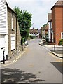
Looking south-southwest along Loop Street
The next road to the left is a cul-de-sac called Stour Court.
Image: © John Baker
Taken: 23 Aug 2015
0.02 miles
3
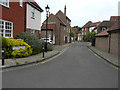
Looking southeast along Tannery Lane
This road is a cul-de-sac of modern, well-designed houses.
Image: © John Baker
Taken: 23 Aug 2015
0.03 miles
6
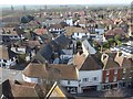
View from the top of St Peter's Church tower
The Church of St Peter is very much at the centre of Sandwich. The present church dates from the late 13th and early 14th centuries, when Sandwich was at the height of its prosperity. The central tower fell in 1661 and destroyed the south aisle which was never re-built. The replacement tower is a 17th-century addition, and was built by Flemish protestant refugees in the style of their homeland churches.
Every day at 8pm, the curfew bell rings out, signalling that the townspeople should cover their fires to make them safe for the night. This was once known as the 'pigbell’, as it also informed people they could release their animals into the street.
The church is Grade I Listed and is under the care of the Churches Conservation Trust. See http://www.visitchurches.org.uk/Ourchurches/Completelistofchurches/St-Peters-Church-Sandwich-Kent/ for more information.
The church is surrounded by attractive buildings as seen here, helped by the fact that Sandwich is the most complete medieval town in England. The impression is of a French or Dutch town because of its Flemish history. This view looks north-west towards Sandwich Windmill, right of centre in the distance.
Image: © Marathon
Taken: 28 Mar 2017
0.04 miles
7

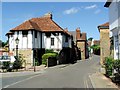
The Butts, Sandwich
This was where men in medieval times had to perform their archery practice. Henry V's archers probably practised here before they sailed to the battle of Agincourt in 1415.
Image: © Nick Smith
Taken: 1 Jul 2007
0.05 miles