IMAGES TAKEN NEAR TO
Spitfire Way, SANDWICH, CT13 9FR
Introduction
This page details the photographs taken nearby to Spitfire Way, CT13 9FR by members of the Geograph project.
The Geograph project started in 2005 with the aim of publishing, organising and preserving representative images for every square kilometre of Great Britain, Ireland and the Isle of Man.

There are currently over 7.5m images from over14,400 individuals and you can help contribute to the project by visiting https://www.geograph.org.uk
Image Map
Images are licensed for reuse under creativecommons.org/licenses/by-sa/2.0
Notes
- Clicking on the map will re-center to the selected point.
- The higher the marker number, the further away the image location is from the centre of the postcode.
Image Listing (8 Images Found)
Images are licensed for reuse under creativecommons.org/licenses/by-sa/2.0
Image
Details
Distance


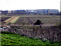
3
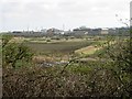
Pfizer, the pharmaceutical company viewed from Richborough castle
Pfizer is a research-based global pharmaceutical company. Pfizer discovers, develops, manufactures and markets leading prescription medicines for humans and animals, as well as many of the world's best-known consumer products.
Image: © Nick Smith
Taken: 29 Mar 2008
0.12 miles
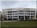
4
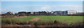
Pfizer, Sandwich
This large business centre is dominated by Pfizer who are the largest employer in the area.
Image: © Oast House Archive
Taken: 27 Jan 2012
0.13 miles
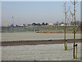
7
Gateway Building. Discovery Park, Sandwich
The Gateway Building is part of the events centre at this science park.
Image: © Richard Rogerson
Taken: 6 Mar 2018
0.19 miles
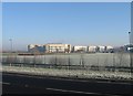
8
The Pfizer research labs from Richborough castle
The site grew enormously from late 1980 until ~2000, the view is mostly buildings on what was named the West Site - ie development to the west of the Sandwich to Ramsgate road. Compare with the photo taken from a similar location in 1977 Image before any development of the West Site had occurred
Image: © Nick Smith
Taken: 29 Mar 2008
0.21 miles