IMAGES TAKEN NEAR TO
Hugin Lane, SANDWICH, CT13 9FG
Introduction
This page details the photographs taken nearby to Hugin Lane, CT13 9FG by members of the Geograph project.
The Geograph project started in 2005 with the aim of publishing, organising and preserving representative images for every square kilometre of Great Britain, Ireland and the Isle of Man.

There are currently over 7.5m images from over14,400 individuals and you can help contribute to the project by visiting https://www.geograph.org.uk
Image Map (Loading...)


Getting Data...Please wait
Leaflet Map data © OpenStreetMap
Images are licensed for reuse under creativecommons.org/licenses/by-sa/2.0
Notes
- Clicking on the map will re-center to the selected point.
- The higher the marker number, the further away the image location is from the centre of the postcode.
Image Listing (32 Images Found)
Images are licensed for reuse under creativecommons.org/licenses/by-sa/2.0
Image
Details
Distance
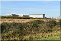
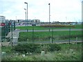
2
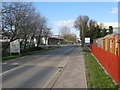
View across ditch towards research centre and car park.
View through security fence towards research centre and car park.
Image: © Nick Smith
Taken: 5 Jan 2007
0.05 miles

5
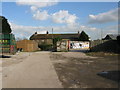
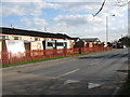
Factory entrance and cottages near Stonar Lake
The left hand cottage is Casita and the right hand one North Lake
Image: © Nick Smith
Taken: 6 Mar 2009
0.10 miles

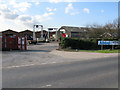
7

Footbridge over Ramsgate Road
Through large expanses of office and research buildings occupied by Pfizer.
Image: © Oast House Archive
Taken: 27 Jan 2012
0.13 miles