IMAGES TAKEN NEAR TO
Bowling Street, SANDWICH, CT13 9EY
Introduction
This page details the photographs taken nearby to Bowling Street, CT13 9EY by members of the Geograph project.
The Geograph project started in 2005 with the aim of publishing, organising and preserving representative images for every square kilometre of Great Britain, Ireland and the Isle of Man.

There are currently over 7.5m images from over14,400 individuals and you can help contribute to the project by visiting https://www.geograph.org.uk
Image Map
Images are licensed for reuse under creativecommons.org/licenses/by-sa/2.0
Notes
- Clicking on the map will re-center to the selected point.
- The higher the marker number, the further away the image location is from the centre of the postcode.
Image Listing (786 Images Found)
Images are licensed for reuse under creativecommons.org/licenses/by-sa/2.0
Image
Details
Distance
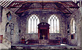
7
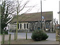
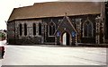
St Mary's church, Sandwich
St. Mary's is the oldest church site in the Ancient Cinque Port of Sandwich and it remains consecrated. More information here http://stmarys.open-sandwich.co.uk/index.htm
Image: © Nick Smith
Taken: 4 Apr 2009
0.02 miles
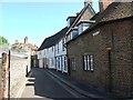
8
![Sandwich houses [14]](https://s1.geograph.org.uk/geophotos/07/06/30/7063013_37ed3b21_120x120.jpg)
Sandwich houses [14]
Strand House, number 55 Strand Street, is an 18th century house, now converted into flats. Constructed of red brick under a tile roof. Listed, grade II, with details at: https://historicengland.org.uk/listing/the-list/list-entry/1069538
Sandwich is a historic town in Kent, situated on the River Stour, 11½ miles east of Canterbury and 10½ miles north of Dover. Once a major port, one of the Cinque Ports, the town is now 2 miles inland due to the silting up of the Wantsum Channel. The town has a great many medieval buildings and was once home to a great many Flemish settlers. In Sandwich Bay are two world-class golf courses.
Image: © Michael Dibb
Taken: 7 Sep 2021
0.03 miles
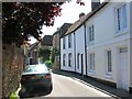
9
![Sandwich houses [15]](https://s2.geograph.org.uk/geophotos/07/06/30/7063014_672138ae_120x120.jpg)
Sandwich houses [15]
River House, number 57 Strand Street, is an 'L' shaped house. Timber framed, probably 15th century but encased in brick in the 18th century, all under a tile roof. Listed, grade II, with details at: https://historicengland.org.uk/listing/the-list/list-entry/1343800
Sandwich is a historic town in Kent, situated on the River Stour, 11½ miles east of Canterbury and 10½ miles north of Dover. Once a major port, one of the Cinque Ports, the town is now 2 miles inland due to the silting up of the Wantsum Channel. The town has a great many medieval buildings and was once home to a great many Flemish settlers. In Sandwich Bay are two world-class golf courses.
Image: © Michael Dibb
Taken: 7 Sep 2021
0.03 miles
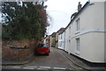
10
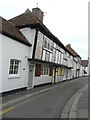
Repairs to Cobwebs, Church Street St Marys
It seemed that repairs were being carried out to the beam between the ground and first floors, at the far end of the house.
Image: © John Baker
Taken: 23 Aug 2015
0.03 miles