IMAGES TAKEN NEAR TO
Strand Street, SANDWICH, CT13 9DU
Introduction
This page details the photographs taken nearby to Strand Street, CT13 9DU by members of the Geograph project.
The Geograph project started in 2005 with the aim of publishing, organising and preserving representative images for every square kilometre of Great Britain, Ireland and the Isle of Man.

There are currently over 7.5m images from over14,400 individuals and you can help contribute to the project by visiting https://www.geograph.org.uk
Image Map
Images are licensed for reuse under creativecommons.org/licenses/by-sa/2.0
Notes
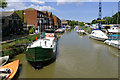
- Clicking on the map will re-center to the selected point.
- The higher the marker number, the further away the image location is from the centre of the postcode.
Image Listing (918 Images Found)
Images are licensed for reuse under creativecommons.org/licenses/by-sa/2.0
Image
Details
Distance
1
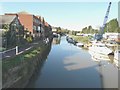
Looking west-northwest along the River Stour
From the bridge carrying Ramsgate Road over the river. The footpath (and access to it from Strand Street) was closed so that the riverside wall could be demolished and built higher. This was in connection with the Sandwich Town Tidal Defence Scheme.
Image: © John Baker
Taken: 30 Oct 2013
0.00 miles
2
The River Stour, Sandwich, Kent
Taken from Town Bridge.
Image: © Cameraman
Taken: 1 Jun 2011
0.00 miles
3
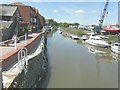
Looking west-northwest along the River Stour
From the bridge that carries Ramsgate Road over the river. Image of October 2013 shows the scene before the new wall along the river bank was erected. This is referred to in Dover District Council’s planning application DOV/13/00690 as the “demolition of existing boundary wall (to rear of 46 and 46A, Strand Street) fronting the River Stour and erection of new flood defence wall”. Unfortunately, the work was not completed before 5 December 2013 when a storm surge caused the river to flood parts of the town.
Image: © John Baker
Taken: 2 Jul 2014
0.00 miles
5
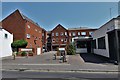
Sandwich, Strand Street: The Aynsley Court housing development
Image: © Michael Garlick
Taken: 26 Jul 2018
0.01 miles
6
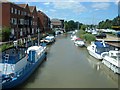
Sandwich Haven and River Stour
Sandwich Haven and River Stour seen from the Old Sandwich Bridge.
Image: © Helmut Zozmann
Taken: 1 Aug 2011
0.01 miles
7
Sandwich Haven and River Stour - 2008
Sandwich Haven and River Stour seen from the Old Sandwich Bridge.
Image: © Helmut Zozmann
Taken: 14 Jul 2008
0.02 miles
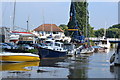
8
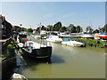
Boats on the River Stour at Sandwich
Picture taken from the toll bridge (Ramsgate Road)
Image: © PAUL FARMER
Taken: 5 Sep 2009
0.02 miles
9
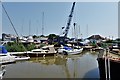
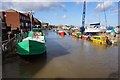
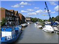
Sandwich, Fishermans Wharf
The crane is lifting a boat out of the water, presumably for servicing.
Image: © Michael Garlick
Taken: 26 Jul 2018
0.02 miles
10
River Stour at Sandwich, looking towards the bridge
Image: © David Martin
Taken: 25 Aug 2013
0.02 miles