IMAGES TAKEN NEAR TO
Strand Street, SANDWICH, CT13 9DS
Introduction
This page details the photographs taken nearby to Strand Street, CT13 9DS by members of the Geograph project.
The Geograph project started in 2005 with the aim of publishing, organising and preserving representative images for every square kilometre of Great Britain, Ireland and the Isle of Man.

There are currently over 7.5m images from over14,400 individuals and you can help contribute to the project by visiting https://www.geograph.org.uk
Image Map
Images are licensed for reuse under creativecommons.org/licenses/by-sa/2.0
Notes
- Clicking on the map will re-center to the selected point.
- The higher the marker number, the further away the image location is from the centre of the postcode.
Image Listing (925 Images Found)
Images are licensed for reuse under creativecommons.org/licenses/by-sa/2.0
Image
Details
Distance
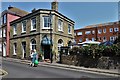
1
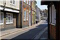
![Sandwich houses [7]](https://s2.geograph.org.uk/geophotos/07/06/29/7062998_68cd3e40_120x120.jpg)
Sandwich houses [7]
Number 30 Strand Street is an early 19th century house. Constructed in red brick under a tile roof. Listed, grade II, with details at: https://historicengland.org.uk/listing/the-list/list-entry/1069547
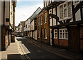
Sandwich is a historic town in Kent, situated on the River Stour, 11½ miles east of Canterbury and 10½ miles north of Dover. Once a major port, one of the Cinque Ports, the town is now 2 miles inland due to the silting up of the Wantsum Channel. The town has a great many medieval buildings and was once home to a great many Flemish settlers. In Sandwich Bay are two world-class golf courses.
Image: © Michael Dibb
Taken: 7 Sep 2021
0.00 miles
3
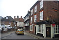
Sandwich, Strand Street: 'Piece of Cake'
Image: © Michael Garlick
Taken: 26 Jul 2018
0.01 miles
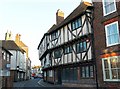
4
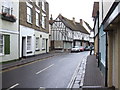
![Sandwich houses [8]](https://s2.geograph.org.uk/geophotos/07/06/30/7063002_b1e3e8ff_120x120.jpg)
Sandwich houses [8]
Numbers 32 and 34 Strand Street are a pair of 16th century houses altered in the 18th century and refronted later. Timber framed, jettied to the street, the ground floor rebuilt in red brick, all under a tile roof in two hips. Listed, grade II, with details at: https://historicengland.org.uk/listing/the-list/list-entry/1121991
Sandwich is a historic town in Kent, situated on the River Stour, 11½ miles east of Canterbury and 10½ miles north of Dover. Once a major port, one of the Cinque Ports, the town is now 2 miles inland due to the silting up of the Wantsum Channel. The town has a great many medieval buildings and was once home to a great many Flemish settlers. In Sandwich Bay are two world-class golf courses.
Image: © Michael Dibb
Taken: 7 Sep 2021
0.01 miles
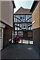
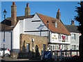
7
Pilgrims House, Sandwich
Two black and white timber framed houses on Strand Street, which have been linked together in the past. Named "The Pilgrims" in the early 20th century, when the premises were used as a hotel and restaurant. The roof peak at the right, now filled in, was once a smuggler's look-out. For more information, see http://www.imagesofengland.org.uk/details/default.aspx?id=177657 .
Image: © Rose and Trev Clough
Taken: 14 Oct 2009
0.02 miles