IMAGES TAKEN NEAR TO
Fordwich Place, SANDWICH, CT13 0RA
Introduction
This page details the photographs taken nearby to Fordwich Place, CT13 0RA by members of the Geograph project.
The Geograph project started in 2005 with the aim of publishing, organising and preserving representative images for every square kilometre of Great Britain, Ireland and the Isle of Man.

There are currently over 7.5m images from over14,400 individuals and you can help contribute to the project by visiting https://www.geograph.org.uk
Image Map
Images are licensed for reuse under creativecommons.org/licenses/by-sa/2.0
Notes
- Clicking on the map will re-center to the selected point.
- The higher the marker number, the further away the image location is from the centre of the postcode.
Image Listing (252 Images Found)
Images are licensed for reuse under creativecommons.org/licenses/by-sa/2.0
Image
Details
Distance
5
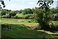
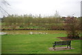
Parkland by the former town moat, Sandwich
There is a long strip of maintained open land between the line of the old wall and the moat.
Image: © Bill Boaden
Taken: 29 Jun 2012
0.10 miles
6

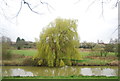
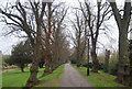
The Rope Walk in Autumn
Sandwich town wall
Image: © John Myers
Taken: 23 Oct 2016
0.10 miles
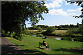
9
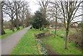
The end of Jubilee Road from Boatman's Hill cemetery
Image: © Nick Smith
Taken: 8 Feb 2008
0.11 miles
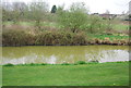
10
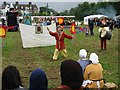
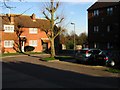
Medieval fayre
Held in a small field near the centre of Sandwich.
Image: © Nick Smith
Taken: 26 Aug 2006
0.11 miles